|
Unofficial Property Record Card - Falmouth, MA
|
|

|
|
General Property Data
|
|
|
| Parcel
ID |
30 01 007 002 |
Account
Number |
WAQUOIT |
| Prior Parcel
ID |
-- |
| Property
Owner |
NYDAM TRUSTEE AUSTIN E |
Property
Location |
441 WAQUOIT HWY |
| |
NYDAM TRUSTEE DAVID A |
Property
Use |
STORE |
| Mailing
Address |
441 WAQUOIT HWY |
Most
Recent
Sale Date |
8/11/2008 |
| |
|
Legal
Reference |
23094-26 |
| City |
EAST FALMOUTH |
Grantor |
NYDAM,AUSTIN E |
| Mailing
State |
|
Sale Price |
100 |
| ParcelZoning |
B2 |
Land Area |
1.375 acres |
|
|
|
|
|
Current Property Assessment
|
|
|
| Card 1 Value |
Building Value |
303,300 |
Xtra Features Value |
10,300 |
Land Value |
345,500 |
Total Value |
659,100 |
|
Total Parcel Value |
Building Value |
303,300 |
Xtra Features Value |
10,300 |
Land Value |
345,500 |
Total Value |
659,100 |
|
|
|
|
|
|
Building Description
|
|
|
| Building
Style |
Store |
Foundation
Type |
|
Flooring
Type |
Conc Slab |
| # of Living
Units |
1 |
Frame
Type |
Wood |
Basement
Floor |
N/A |
| Year
Built |
1940 |
Roof
Structure |
Gable/Hip |
Heating
Type |
Frcd Hot Air |
| Building
Grade |
4 1.1 |
Roof
Cover |
Asphalt |
Heating
Fuel |
Gas |
| Building
Condition |
Average |
Siding |
Wood Shingle |
Air
Conditioning |
0% |
| Finished
Area (SF) |
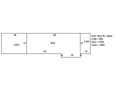
3756 |
Interior
Walls |
Drywall |
# of Bsmt
Garages |
0 |
| Number
Rooms |
0 |
# of
Bedrooms |
0 |
# of Full
Baths |
0 |
| # of 3/4
Baths |
0 |
# of 1/2
Baths |
0 |
# of Other
Fixtures |
0 |
|
|
|
|
| Legal Description
|
|
|
|
PARENT LOT 30 01 005 004 & 30 01 007 002/PLAN 543/73`96
|
|
|
| Narrative Description of Property
|
|
|
|
This property contains 1.375 acres of land mainly classified as
STORE
with a(n) Store style building, built about
1940 , having Wood Shingle exterior and Asphalt
roof cover, with 1
unit(s), 0
room(s), 0
bedroom(s), 0
bath(s), 0 half bath(s). |
|
|
|
| Property Images
|
|
|