|
Unofficial Property Record Card - Falmouth, MA
|
|

|
|
General Property Data
|
|
|
| Parcel
ID |
31 01 008A 000B |
Account
Number |
WAQUOIT |
| Prior Parcel
ID |
-- |
| Property
Owner |
OZV PE 3 CAPE WPB LLC |
Property
Location |
169 METOXIT RD |
| |
|
Property
Use |
ONE FAMILY |
| Mailing
Address |
9 AVENUE AT PORT IMPERIAL |
Most
Recent
Sale Date |
4/25/2022 |
| |
APT 414 |
Legal
Reference |
35068-344 |
| City |
WEST NEW YORK |
Grantor |
CAPE COD OZ PROPERTY II LLC, |
| Mailing
State |
|
Sale Price |
1 |
| ParcelZoning |
RA |
Land Area |
1.483 acres |
|
|
|
|
|
Current Property Assessment
|
|
|
| Card 1 Value |
Building Value |
478,900 |
Xtra Features Value |
29,000 |
Land Value |
984,000 |
Total Value |
1,491,900 |
|
Total Parcel Value |
Building Value |
478,900 |
Xtra Features Value |
29,000 |
Land Value |
984,000 |
Total Value |
1,491,900 |
|
|
|
|
|
| Legal Description
|
|
|
|
|
|
|
| Narrative Description of Property
|
|
|
|
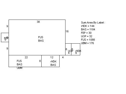
This property contains 1.483 acres of land mainly classified as
ONE FAMILY
with a(n) Colonial style building, built about
1958 , having Wood Shingle exterior and Asphalt
roof cover, with 1
unit(s), 6
room(s), 3
bedroom(s), 4
bath(s), 1 half bath(s). |
|