|
Unofficial Property Record Card - Falmouth, MA
|
|

|
|
General Property Data
|
|
|
| Parcel
ID |
32 06 000 138 |
Account
Number |
EAST FALMOUTH |
| Prior Parcel
ID |
-- |
| Property
Owner |
COVENEY TRUSTEE WILLIAM P |
Property
Location |
133 ANTLERS SHORE DR |
| |
COVENEY TRUSTEE MARY ANNE |
Property
Use |
ONE FAMILY |
| Mailing
Address |
6 LEE ANN CIR |
Most
Recent
Sale Date |
8/3/2021 |
| |
|
Legal
Reference |
34353-163 |
| City |
WESTBOROUGH |
Grantor |
SHEEHAN TRUSTEE,WILLIAM J |
| Mailing
State |
|
Sale Price |
342,500 |
| ParcelZoning |
RC |
Land Area |
0.285 acres |
|
|
|
|
|
Current Property Assessment
|
|
|
| Card 1 Value |
Building Value |
243,700 |
Xtra Features Value |
1,300 |
Land Value |
242,700 |
Total Value |
487,700 |
|
Total Parcel Value |
Building Value |
243,700 |
Xtra Features Value |
1,300 |
Land Value |
242,700 |
Total Value |
487,700 |
|
|
|
|
|
|
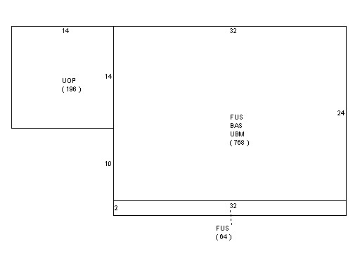
Building Description
|
|
|
| Building
Style |
Colonial |
Foundation
Type |
Concrete |
Flooring
Type |
Hardwood |
| # of Living
Units |
1 |
Frame
Type |
Wood |
Basement
Floor |
Conc Slab |
| Year
Built |
1972 |
Roof
Structure |
Gable/Hip |
Heating
Type |
Hot Water |
| Building
Grade |
4 1.1 |
Roof
Cover |
Asphalt |
Heating
Fuel |
Gas |
| Building
Condition |
Average |
Siding |
Wood Shingle |
Air
Conditioning |
0% |
| Finished
Area (SF) |
1600 |
Interior
Walls |
Drywall |
# of Bsmt
Garages |
0 |
| Number
Rooms |
7 |
# of
Bedrooms |
4 |
# of Full
Baths |
1 |
| # of 3/4
Baths |
0 |
# of 1/2
Baths |
1 |
# of Other
Fixtures |
0 |
|
|
|
|
| Legal Description
|
|
|
|
|
|
|
| Narrative Description of Property
|
|
|
|
This property contains 0.285 acres of land mainly classified as
ONE FAMILY
with a(n) Colonial style building, built about
1972 , having Wood Shingle exterior and Asphalt
roof cover, with 1
unit(s), 7
room(s), 4
bedroom(s), 1
bath(s), 1 half bath(s). |
|
|
|
| Property Images
|
|
|