|
Unofficial Property Record Card - Falmouth, MA
|
|

|
|
General Property Data
|
|
|
| Parcel
ID |
32 13 000D 055 |
Account
Number |
SEACOAST SHORES |
| Prior Parcel
ID |
-- |
| Property
Owner |
ODONNELL GAIL A |
Property
Location |
43 ATWATER DR |
| |
ODONNELL THOMAS F |
Property
Use |
ONE FAMILY |
| Mailing
Address |
33 MT VERNON ST |
Most
Recent
Sale Date |
10/29/2021 |
| |
|
Legal
Reference |
34617-47 |
| City |
READING |
Grantor |
LLOYD,STEVEN G |
| Mailing
State |
|
Sale Price |
575,000 |
| ParcelZoning |
RC |
Land Area |
0.186 acres |
|
|
|
|
|
Current Property Assessment
|
|
|
| Card 1 Value |
Building Value |
420,900 |
Xtra Features Value |
6,800 |
Land Value |
151,400 |
Total Value |
579,100 |
|
Total Parcel Value |
Building Value |
420,900 |
Xtra Features Value |
6,800 |
Land Value |
151,400 |
Total Value |
579,100 |
|
|
|
|
|
|
Building Description
|
|
|
| Building
Style |
Ranch |
Foundation
Type |
Concrete |
Flooring
Type |
Hardwood |
| # of Living
Units |
1 |
Frame
Type |
Wood |
Basement
Floor |
N/A |
| Year
Built |
1987 |
Roof
Structure |
Gable/Hip |
Heating
Type |
Frcd Hot Air |
| Building
Grade |
5 1.20 |
Roof
Cover |
Asphalt |
Heating
Fuel |
Gas |
| Building
Condition |
Average |
Siding |
Vinyl Siding |
Air
Conditioning |
100% |
| Finished
Area (SF) |
1552 |
Interior
Walls |
Drywall |
# of Bsmt
Garages |
0 |
| Number
Rooms |
4 |
# of
Bedrooms |
2 |
# of Full
Baths |
2 |
| # of 3/4
Baths |
0 |
# of 1/2
Baths |
0 |
# of Other
Fixtures |
2 |
|
|
|
|
| Legal Description
|
|
|
|
|
|
|
| Narrative Description of Property
|
|
|
|
This property contains 0.186 acres of land mainly classified as
ONE FAMILY
with a(n) Ranch style building, built about
1987 , having Vinyl Siding exterior and Asphalt
roof cover, with 1
unit(s), 4
room(s), 2
bedroom(s), 2
bath(s), 0 half bath(s). |
|
|
|
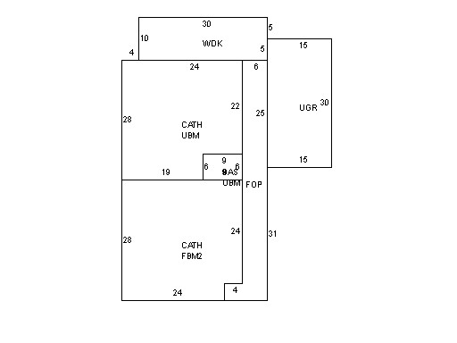
| Property Images
|
|
|