|
Unofficial Property Record Card - Falmouth, MA
|
|

|
|
General Property Data
|
|
|
| Parcel
ID |
33 13 012 000 |
Account
Number |
EAST FALMOUTH |
| Prior Parcel
ID |
RENO -- |
| Property
Owner |
JAKES TAP INC |
Property
Location |
363 EAST FALMOUTH HWY |
| |
|
Property
Use |
RST/BAR |
| Mailing
Address |
12 RIVERSIDE DR |
Most
Recent
Sale Date |
1/31/1975 |
| |
C/O DUNKIN DONUTS JOHN CADETE |
Legal
Reference |
51400-2600 |
| City |
PEMBROKE |
Grantor |
|
| Mailing
State |
|
Sale Price |
0 |
| ParcelZoning |
B2 |
Land Area |
0.819 acres |
|
|
|
|
|
Current Property Assessment
|
|
|
| Card 1 Value |
Building Value |
639,900 |
Xtra Features Value |
39,200 |
Land Value |
570,800 |
Total Value |
1,249,900 |
|
Total Parcel Value |
Building Value |
639,900 |
Xtra Features Value |
39,200 |
Land Value |
570,800 |
Total Value |
1,249,900 |
|
|
|
|
|
|
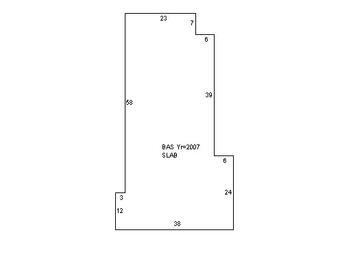
Building Description
|
|
|
| Building
Style |
Fast Food |
Foundation
Type |
Slab |
Flooring
Type |
Ceramic Tile |
| # of Living
Units |
0 |
Frame
Type |
Wood |
Basement
Floor |
N/A |
| Year
Built |
2007 |
Roof
Structure |
Gable/Hip |
Heating
Type |
Frcd Hot Air |
| Building
Grade |
6 1.35 |
Roof
Cover |
Asphalt |
Heating
Fuel |
Gas |
| Building
Condition |
Average |
Siding |
Clapboard |
Air
Conditioning |
100% |
| Finished
Area (SF) |
2168 |
Interior
Walls |
Drywall |
# of Bsmt
Garages |
0 |
| Number
Rooms |
0 |
# of
Bedrooms |
0 |
# of Full
Baths |
0 |
| # of 3/4
Baths |
0 |
# of 1/2
Baths |
2 |
# of Other
Fixtures |
0 |
|
|
|
|
| Legal Description
|
|
|
|
|
|
|
| Narrative Description of Property
|
|
|
|
This property contains 0.819 acres of land mainly classified as
RST/BAR
with a(n) Fast Food style building, built about
2007 , having Clapboard exterior and Asphalt
roof cover, with 0
unit(s), 0
room(s), 0
bedroom(s), 0
bath(s), 2 half bath(s). |
|
|
|
| Property Images
|
|
|