|
Unofficial Property Record Card - Falmouth, MA
|
|

|
|
General Property Data
|
|
|
| Parcel
ID |
33 18 019A 000B |
Account
Number |
EAST FALMOUTH |
| Prior Parcel
ID |
-- |
| Property
Owner |
FALMOUTH TOWN OF |
Property
Location |
505 EAST FALMOUTH HWY |
| |
|
Property
Use |
IMP PUB SAFE |
| Mailing
Address |
59 TOWN HALL SQ |
Most
Recent
Sale Date |
1/3/1977 |
| |
|
Legal
Reference |
02450-0248 |
| City |
FALMOUTH |
Grantor |
|
| Mailing
State |
|
Sale Price |
0 |
| ParcelZoning |
RC |
Land Area |
1.428 acres |
|
|
|
|
|
Current Property Assessment
|
|
|
| Card 1 Value |
Building Value |
1,242,200 |
Xtra Features Value |
0 |
Land Value |
294,700 |
Total Value |
1,536,900 |
|
Total Parcel Value |
Building Value |
1,242,200 |
Xtra Features Value |
0 |
Land Value |
294,700 |
Total Value |
1,536,900 |
|
|
|
|
|
|
Building Description
|
|
|
| Building
Style |
Fire Station |
Foundation
Type |
|
Flooring
Type |
Asph Tile |
| # of Living
Units |
0 |
Frame
Type |
Masonry |
Basement
Floor |
N/A |
| Year
Built |
1981 |
Roof
Structure |
Gable/Hip |
Heating
Type |
Hot Water |
| Building
Grade |
8 1.85 |
Roof
Cover |
Asphalt |
Heating
Fuel |
Gas |
| Building
Condition |
Average |
Siding |
Brick Veneer |
Air
Conditioning |
0% |
| Finished
Area (SF) |
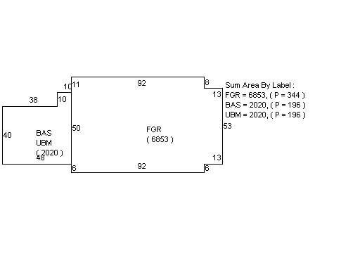
2020 |
Interior
Walls |
Drywall |
# of Bsmt
Garages |
0 |
| Number
Rooms |
0 |
# of
Bedrooms |
0 |
# of Full
Baths |
2 |
| # of 3/4
Baths |
0 |
# of 1/2
Baths |
0 |
# of Other
Fixtures |
0 |
|
|
|
|
| Legal Description
|
|
|
|
|
|
|
| Narrative Description of Property
|
|
|
|
This property contains 1.428 acres of land mainly classified as
IMP PUB SAFE
with a(n) Fire Station style building, built about
1981 , having Brick Veneer exterior and Asphalt
roof cover, with 0
unit(s), 0
room(s), 0
bedroom(s), 2
bath(s), 0 half bath(s). |
|
|
|
| Property Images
|
|
|