|
Unofficial Property Record Card - Falmouth, MA
|
|

|
|
General Property Data
|
|
|
| Parcel
ID |
04A 43 000 000E |
Account
Number |
SILVER BEACH |
| Prior Parcel
ID |
-- |
| Property
Owner |
DUGGAN TRUSTEE THOMAS P |
Property
Location |
11 ROCK ST |
| |
DUGGAN TRUSTEE CATHERINE A |
Property
Use |
ONE FAMILY |
| Mailing
Address |
62 OAK RD |
Most
Recent
Sale Date |
8/12/2019 |
| |
|
Legal
Reference |
220220 |
| City |
CANTON |
Grantor |
DUGGAN,CATHERINE A |
| Mailing
State |
|
Sale Price |
100 |
| ParcelZoning |
RC |
Land Area |
0.131 acres |
|
|
|
|
|
Current Property Assessment
|
|
|
| Card 1 Value |
Building Value |
291,700 |
Xtra Features Value |
40,200 |
Land Value |
1,400,200 |
Total Value |
1,732,100 |
|
Total Parcel Value |
Building Value |
291,700 |
Xtra Features Value |
40,200 |
Land Value |
1,400,200 |
Total Value |
1,732,100 |
|
|
|
|
|
| Legal Description
|
|
|
|
|
|
|
| Narrative Description of Property
|
|
|
|
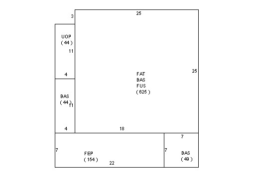
This property contains 0.131 acres of land mainly classified as
ONE FAMILY
with a(n) Colonial style building, built about
1935 , having Vinyl Shingl exterior and Asphalt
roof cover, with 1
unit(s), 7
room(s), 3
bedroom(s), 2
bath(s), 2 half bath(s). |
|