|
Unofficial Property Record Card - Falmouth, MA
|
|

|
|
General Property Data
|
|
|
| Parcel
ID |
34 04 028 009 |
Account
Number |
TEATICKET |
| Prior Parcel
ID |
-- |
| Property
Owner |
BAKER ROBERT |
Property
Location |
39 HOMESTEAD LN |
| |
|
Property
Use |
ONE FAMILY |
| Mailing
Address |
609 SOUTH ST |
Most
Recent
Sale Date |
8/25/2006 |
| |
|
Legal
Reference |
21300-317 |
| City |
WALPOLE |
Grantor |
BAKER,ROBERT |
| Mailing
State |
|
Sale Price |
1 |
| ParcelZoning |
AGB |
Land Area |
0.395 acres |
|
|
|
|
|
Current Property Assessment
|
|
|
| Card 1 Value |
Building Value |
162,900 |
Xtra Features Value |
0 |
Land Value |
152,100 |
Total Value |
315,000 |
|
Total Parcel Value |
Building Value |
162,900 |
Xtra Features Value |
0 |
Land Value |
152,100 |
Total Value |
315,000 |
|
|
|
|
|
|
Building Description
|
|
|
| Building
Style |
Ranch |
Foundation
Type |
Conc Block |
Flooring
Type |
Hardwood |
| # of Living
Units |
1 |
Frame
Type |
Wood |
Basement
Floor |
Conc Slab |
| Year
Built |
1963 |
Roof
Structure |
Gable/Hip |
Heating
Type |
Hot Water |
| Building
Grade |
4 1.1 |
Roof
Cover |
Asphalt |
Heating
Fuel |
Oil |
| Building
Condition |
Average |
Siding |
Wood Shingle |
Air
Conditioning |
0% |
| Finished
Area (SF) |
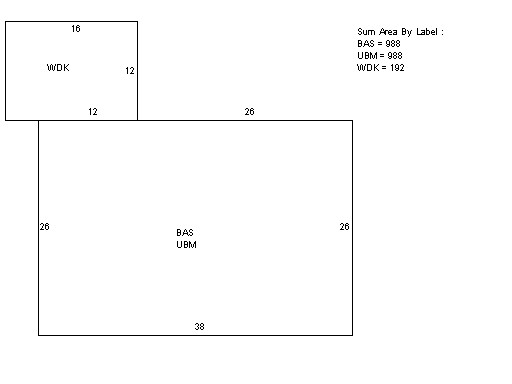
988 |
Interior
Walls |
Drywall |
# of Bsmt
Garages |
0 |
| Number
Rooms |
6 |
# of
Bedrooms |
3 |
# of Full
Baths |
1 |
| # of 3/4
Baths |
0 |
# of 1/2
Baths |
0 |
# of Other
Fixtures |
0 |
|
|
|
|
| Legal Description
|
|
|
|
|
|
|
| Narrative Description of Property
|
|
|
|
This property contains 0.395 acres of land mainly classified as
ONE FAMILY
with a(n) Ranch style building, built about
1963 , having Wood Shingle exterior and Asphalt
roof cover, with 1
unit(s), 6
room(s), 3
bedroom(s), 1
bath(s), 0 half bath(s). |
|
|
|
| Property Images
|
|
|