|
Unofficial Property Record Card - Falmouth, MA
|
|

|
|
General Property Data
|
|
|
| Parcel
ID |
36 03 019 243 |
Account
Number |
WEST FALMOUTH |
| Prior Parcel
ID |
-- |
| Property
Owner |
FLINT TRUSTEE NANCY S |
Property
Location |
162 SACONESSET RD |
| |
FLINT JR TRUSTEE LORING S |
Property
Use |
ONE FAMILY |
| Mailing
Address |
162 SACONESSET RD |
Most
Recent
Sale Date |
2/20/2018 |
| |
|
Legal
Reference |
215440 |
| City |
FALMOUTH |
Grantor |
FLINT JR,LORING S |
| Mailing
State |
|
Sale Price |
1 |
| ParcelZoning |
RB |
Land Area |
1.038 acres |
|
|
|
|
|
Current Property Assessment
|
|
|
| Card 1 Value |
Building Value |
1,847,500 |
Xtra Features Value |
7,900 |
Land Value |
1,821,600 |
Total Value |
3,677,000 |
|
Total Parcel Value |
Building Value |
1,971,600 |
Xtra Features Value |
45,900 |
Land Value |
1,821,600 |
Total Value |
3,839,100 |
|
|
|
|
|
| Legal Description
|
|
|
|
|
|
|
| Narrative Description of Property
|
|
|
|
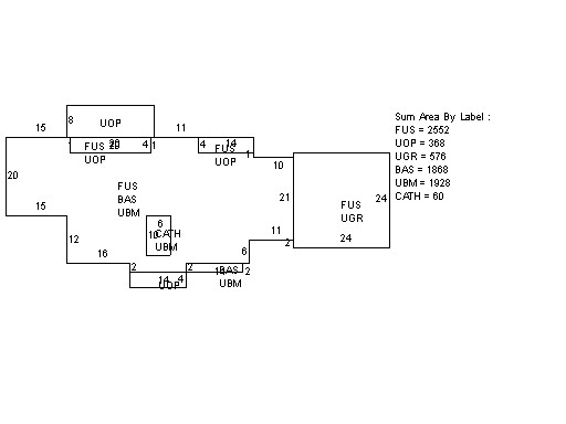
This property contains 1.038 acres of land mainly classified as
ONE FAMILY
with a(n) Custom style building, built about
2015 , having Wood Shingle exterior and Asphalt
roof cover, with 0
unit(s), 12
room(s), 5
bedroom(s), 1
bath(s), 1 half bath(s). |
|