|
Unofficial Property Record Card - Falmouth, MA
|
|

|
|
General Property Data
|
|
|
| Parcel
ID |
36 04 001 079 |
Account
Number |
WEST FALMOUTH |
| Prior Parcel
ID |
-- |
| Property
Owner |
LONG DEBORAH L E |
Property
Location |
116 SACONESSET RD |
| |
|
Property
Use |
ONE FAMILY |
| Mailing
Address |
140 WYOMING AVE |
Most
Recent
Sale Date |
9/22/2022 |
| |
|
Legal
Reference |
231126 |
| City |
NEEDHAM |
Grantor |
KURLAT TRUSTEE,SAUL |
| Mailing
State |
|
Sale Price |
1 |
| ParcelZoning |
RB |
Land Area |
0.948 acres |
|
|
|
|
|
Current Property Assessment
|
|
|
| Card 1 Value |
Building Value |
527,400 |
Xtra Features Value |
16,900 |
Land Value |
882,600 |
Total Value |
1,426,900 |
|
Total Parcel Value |
Building Value |
527,400 |
Xtra Features Value |
16,900 |
Land Value |
882,600 |
Total Value |
1,426,900 |
|
|
|
|
|
| Legal Description
|
|
|
|
|
|
|
| Narrative Description of Property
|
|
|
|
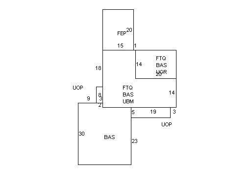
This property contains 0.948 acres of land mainly classified as
ONE FAMILY
with a(n) Cape Cod style building, built about
1950 , having Wood Shingle exterior and Asphalt
roof cover, with 1
unit(s), 7
room(s), 4
bedroom(s), 4
bath(s), 1 half bath(s). |
|