|
Unofficial Property Record Card - Falmouth, MA
|
|

|
|
General Property Data
|
|
|
| Parcel
ID |
37 10 003 059A |
Account
Number |
SIPPEWISSETT |
| Prior Parcel
ID |
-- |
| Property
Owner |
SEIBT DALE R |
Property
Location |
19 GUNNING POINT AVE |
| |
SEIBT KRISTIN C |
Property
Use |
ONE FAMILY |
| Mailing
Address |
19 GUNNING POINT RD |
Most
Recent
Sale Date |
7/9/2018 |
| |
|
Legal
Reference |
31390-241 |
| City |
FALMOUTH |
Grantor |
SEIBT,DALE R |
| Mailing
State |
|
Sale Price |
1 |
| ParcelZoning |
RB |
Land Area |
0.847 acres |
|
|
|
|
|
Current Property Assessment
|
|
|
| Card 1 Value |
Building Value |
828,900 |
Xtra Features Value |
13,200 |
Land Value |
914,500 |
Total Value |
1,756,600 |
|
Total Parcel Value |
Building Value |
828,900 |
Xtra Features Value |
13,200 |
Land Value |
914,500 |
Total Value |
1,756,600 |
|
|
|
|
|
| Legal Description
|
|
|
|
|
|
|
| Narrative Description of Property
|
|
|
|
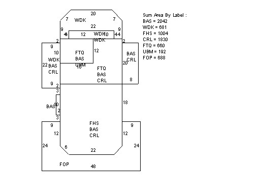
This property contains 0.847 acres of land mainly classified as
ONE FAMILY
with a(n) Conventional style building, built about
1918 , having Wood Shingle exterior and Asphalt
roof cover, with 1
unit(s), 8
room(s), 4
bedroom(s), 1
bath(s), 1 half bath(s). |
|