|
Unofficial Property Record Card - Falmouth, MA
|
|

|
|
General Property Data
|
|
|
| Parcel
ID |
40 12 007B 006 |
Account
Number |
EAST FALMOUTH |
| Prior Parcel
ID |
-- |
| Property
Owner |
WILLIAMS TRUSTEE C MICHELE |
Property
Location |
250 DAVISVILLE RD |
| |
SEA SWEPT REALTY TRUST |
Property
Use |
MULT HS |
| Mailing
Address |
690 SARATOGA RD |
Most
Recent
Sale Date |
1/8/2002 |
| |
# 134 |
Legal
Reference |
163943 |
| City |
BURNT HILLS |
Grantor |
WILLIAMS KYLE G TRUSTEE |
| Mailing
State |
|
Sale Price |
0 |
| ParcelZoning |
RC |
Land Area |
0.771 acres |
|
|
|
|
|
Current Property Assessment
|
|
|
| Card 1 Value |
Building Value |
192,600 |
Xtra Features Value |
0 |
Land Value |
169,900 |
Total Value |
362,500 |
|
Total Parcel Value |
Building Value |
491,000 |
Xtra Features Value |
12,500 |
Land Value |
169,900 |
Total Value |
673,400 |
|
|
|
|
|
|
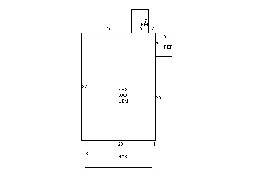
Building Description
|
|
|
| Building
Style |
Family Conv |
Foundation
Type |
Conc Block |
Flooring
Type |
Hardwood |
| # of Living
Units |
0 |
Frame
Type |
Wood |
Basement
Floor |
N/A |
| Year
Built |
1930 |
Roof
Structure |
Gable/Hip |
Heating
Type |
Hot Water |
| Building
Grade |
4 1.1 |
Roof
Cover |
Asphalt |
Heating
Fuel |
Gas |
| Building
Condition |
Average |
Siding |
Wood Shingle |
Air
Conditioning |
0% |
| Finished
Area (SF) |
1392 |
Interior
Walls |
Plaster |
# of Bsmt
Garages |
0 |
| Number
Rooms |
7 |
# of
Bedrooms |
4 |
# of Full
Baths |
2 |
| # of 3/4
Baths |
0 |
# of 1/2
Baths |
0 |
# of Other
Fixtures |
0 |
|
|
|
|
| Legal Description
|
|
|
|
|
|
|
| Narrative Description of Property
|
|
|
|
This property contains 0.771 acres of land mainly classified as
MULT HS
with a(n) Family Conv style building, built about
1930 , having Wood Shingle exterior and Asphalt
roof cover, with 0
unit(s), 7
room(s), 4
bedroom(s), 2
bath(s), 0 half bath(s). |
|
|
|
| Property Images
|
|
|