|
Unofficial Property Record Card - Falmouth, MA
|
|

|
|
General Property Data
|
|
|
| Parcel
ID |
40A 28 003 043 |
Account
Number |
MENAUHANT |
| Prior Parcel
ID |
-- |
| Property
Owner |
HALLAGAN ROBERT E |
Property
Location |
49 BOURNES POND RD |
| |
HALLAGAN HARRIETT H |
Property
Use |
ONE FAMILY |
| Mailing
Address |
27 DOVER RD |
Most
Recent
Sale Date |
3/2/2001 |
| |
|
Legal
Reference |
160805 |
| City |
DOVER |
Grantor |
BUTTS FREDERIC H II |
| Mailing
State |
|
Sale Price |
1,275,000 |
| ParcelZoning |
RB |
Land Area |
0.852 acres |
|
|
|
|
|
Current Property Assessment
|
|
|
| Card 1 Value |
Building Value |
994,100 |
Xtra Features Value |
16,400 |
Land Value |
1,286,500 |
Total Value |
2,297,000 |
|
Total Parcel Value |
Building Value |
1,029,600 |
Xtra Features Value |
16,400 |
Land Value |
1,286,500 |
Total Value |
2,332,500 |
|
|
|
|
|
| Legal Description
|
|
|
|
|
|
|
| Narrative Description of Property
|
|
|
|
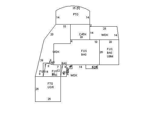
This property contains 0.852 acres of land mainly classified as
ONE FAMILY
with a(n) Conventional style building, built about
1925 , having Wood Shingle exterior and Asphalt
roof cover, with 1
unit(s), 8
room(s), 5
bedroom(s), 6
bath(s), 0 half bath(s). |
|