|
Unofficial Property Record Card - Falmouth, MA
|
|

|
|
General Property Data
|
|
|
| Parcel
ID |
45 10 000 078 |
Account
Number |
MENAUHANT |
| Prior Parcel
ID |
SIDING -BATH- |
| Property
Owner |
LEVY WILLIAM R |
Property
Location |
279 MENAUHANT RD |
| |
LEVY DEBRA RICCIO |
Property
Use |
ONE FAMILY |
| Mailing
Address |
279 MENAUHANT RD |
Most
Recent
Sale Date |
2/6/1998 |
| |
|
Legal
Reference |
147435 |
| City |
E FALMOUTH |
Grantor |
DANGELO JOHN H TRUSTEE |
| Mailing
State |
|
Sale Price |
309,900 |
| ParcelZoning |
RB |
Land Area |
0.341 acres |
|
|
|
|
|
Current Property Assessment
|
|
|
| Card 1 Value |
Building Value |
499,100 |
Xtra Features Value |
1,600 |
Land Value |
374,400 |
Total Value |
875,100 |
|
Total Parcel Value |
Building Value |
499,100 |
Xtra Features Value |
1,600 |
Land Value |
374,400 |
Total Value |
875,100 |
|
|
|
|
|
|
Building Description
|
|
|
| Building
Style |
Cape Cod |
Foundation
Type |
Concrete |
Flooring
Type |
Hardwood |
| # of Living
Units |
1 |
Frame
Type |
Wood |
Basement
Floor |
Conc Slab |
| Year
Built |
1997 |
Roof
Structure |
Gable/Hip |
Heating
Type |
Hot Water |
| Building
Grade |
6 1.35 |
Roof
Cover |
Asphalt |
Heating
Fuel |
Gas |
| Building
Condition |
Average |
Siding |
Wood Shingle |
Air
Conditioning |
100% |
| Finished
Area (SF) |
2444 |
Interior
Walls |
Drywall |
# of Bsmt
Garages |
0 |
| Number
Rooms |
7 |
# of
Bedrooms |
4 |
# of Full
Baths |
2 |
| # of 3/4
Baths |
0 |
# of 1/2
Baths |
1 |
# of Other
Fixtures |
0 |
|
|
|
|
| Legal Description
|
|
|
|
|
|
|
| Narrative Description of Property
|
|
|
|
This property contains 0.341 acres of land mainly classified as
ONE FAMILY
with a(n) Cape Cod style building, built about
1997 , having Wood Shingle exterior and Asphalt
roof cover, with 1
unit(s), 7
room(s), 4
bedroom(s), 2
bath(s), 1 half bath(s). |
|
|
|
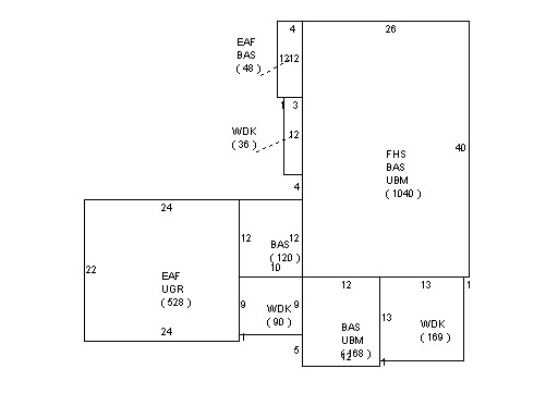
| Property Images
|
|
|