|
Unofficial Property Record Card - Falmouth, MA
|
|

|
|
General Property Data
|
|
|
| Parcel
ID |
45 21 000 020 |
Account
Number |
EAST FALMOUTH |
| Prior Parcel
ID |
-- |
| Property
Owner |
MCGANN WILLIAM J |
Property
Location |
5 FOSTER RD |
| |
|
Property
Use |
ONE FAMILY |
| Mailing
Address |
1228 KING PHILIP ST |
Most
Recent
Sale Date |
11/7/2003 |
| |
|
Legal
Reference |
171157 |
| City |
RAYNHAM |
Grantor |
MCGANN,WILLIAM J |
| Mailing
State |
|
Sale Price |
1 |
| ParcelZoning |
RB |
Land Area |
0.698 acres |
|
|
|
|
|
Current Property Assessment
|
|
|
| Card 1 Value |
Building Value |
1,014,800 |
Xtra Features Value |
0 |
Land Value |
2,198,400 |
Total Value |
3,213,200 |
|
Total Parcel Value |
Building Value |
1,014,800 |
Xtra Features Value |
0 |
Land Value |
2,198,400 |
Total Value |
3,213,200 |
|
|
|
|
|
| Legal Description
|
|
|
|
|
|
|
| Narrative Description of Property
|
|
|
|
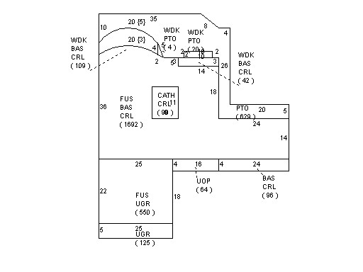
This property contains 0.698 acres of land mainly classified as
ONE FAMILY
with a(n) Contemporary style building, built about
2004 , having Wood on Shth exterior and Asphalt
roof cover, with 1
unit(s), 8
room(s), 3
bedroom(s), 1
bath(s), 1 half bath(s). |
|