|
Unofficial Property Record Card - Falmouth, MA
|
|

|
|
General Property Data
|
|
|
| Parcel
ID |
46 00G 000 019 |
Account
Number |
FALMOUTH HEIGHTS |
| Prior Parcel
ID |
-- |
| Property
Owner |
MCINNIS TRUSTEE MICHAEL P |
Property
Location |
42 HUDSON ST |
| |
MCINNIS III TRUSTEE JAMES F |
Property
Use |
ONE FAMILY |
| Mailing
Address |
42 HUDSON ST |
Most
Recent
Sale Date |
6/7/2021 |
| |
|
Legal
Reference |
34186-64 |
| City |
FALMOUTH |
Grantor |
MCINNIS,JAMES F |
| Mailing
State |
|
Sale Price |
100 |
| ParcelZoning |
RC |
Land Area |
0.279 acres |
|
|
|
|
|
Current Property Assessment
|
|
|
| Card 1 Value |
Building Value |
610,900 |
Xtra Features Value |
75,000 |
Land Value |
340,300 |
Total Value |
1,026,200 |
|
Total Parcel Value |
Building Value |
610,900 |
Xtra Features Value |
75,000 |
Land Value |
340,300 |
Total Value |
1,026,200 |
|
|
|
|
|
| Legal Description
|
|
|
|
|
|
|
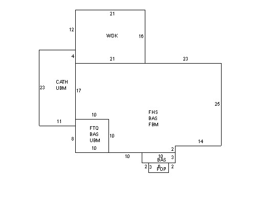
| Narrative Description of Property
|
|
|
|
This property contains 0.279 acres of land mainly classified as
ONE FAMILY
with a(n) Cape Cod style building, built about
1960 , having Wood Shingle exterior and Asphalt
roof cover, with 1
unit(s), 7
room(s), 4
bedroom(s), 0
bath(s), 1 half bath(s). |
|