|
Unofficial Property Record Card - Falmouth, MA
|
|

|
|
General Property Data
|
|
|
| Parcel
ID |
46 00M 000 011 |
Account
Number |
FALMOUTH HEIGHTS |
| Prior Parcel
ID |
SIDING -- |
| Property
Owner |
LOONEY III WILLIAM F |
Property
Location |
8 JOHNSON ST |
| |
LOONEY EILEEN P |
Property
Use |
ONE FAMILY |
| Mailing
Address |
182 COMMONWEALTH AVE |
Most
Recent
Sale Date |
6/22/2015 |
| |
|
Legal
Reference |
28957-260 |
| City |
CHESTNUT HILL |
Grantor |
LABERIS TRUSTEE,WILLIAM E |
| Mailing
State |
|
Sale Price |
575,500 |
| ParcelZoning |
RC |
Land Area |
0.202 acres |
|
|
|
|
|
Current Property Assessment
|
|
|
| Card 1 Value |
Building Value |
411,400 |
Xtra Features Value |
5,600 |
Land Value |
327,200 |
Total Value |
744,200 |
|
Total Parcel Value |
Building Value |
411,400 |
Xtra Features Value |
5,600 |
Land Value |
327,200 |
Total Value |
744,200 |
|
|
|
|
|
|
Building Description
|
|
|
| Building
Style |
Cape Cod |
Foundation
Type |
Concrete |
Flooring
Type |
Hardwood |
| # of Living
Units |
1 |
Frame
Type |
Wood |
Basement
Floor |
N/A |
| Year
Built |
1950 |
Roof
Structure |
Gable/Hip |
Heating
Type |
Frcd Hot Air |
| Building
Grade |
6 1.35 |
Roof
Cover |
Asphalt |
Heating
Fuel |
Gas |
| Building
Condition |
Average |
Siding |
Wood Shingle |
Air
Conditioning |
100% |
| Finished
Area (SF) |
2054 |
Interior
Walls |
Drywall |
# of Bsmt
Garages |
0 |
| Number
Rooms |
7 |
# of
Bedrooms |
4 |
# of Full
Baths |
1 |
| # of 3/4
Baths |
1 |
# of 1/2
Baths |
0 |
# of Other
Fixtures |
1 |
|
|
|
|
| Legal Description
|
|
|
|
|
|
|
| Narrative Description of Property
|
|
|
|
This property contains 0.202 acres of land mainly classified as
ONE FAMILY
with a(n) Cape Cod style building, built about
1950 , having Wood Shingle exterior and Asphalt
roof cover, with 1
unit(s), 7
room(s), 4
bedroom(s), 1
bath(s), 0 half bath(s). |
|
|
|
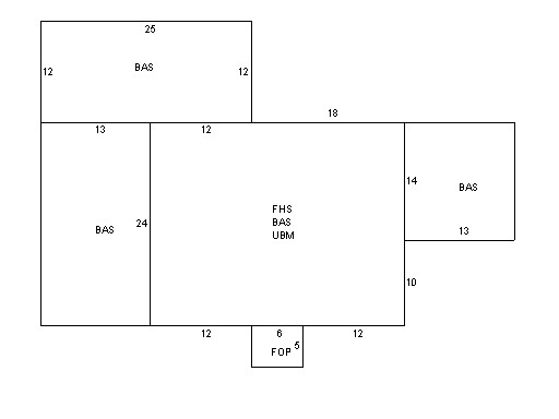
| Property Images
|
|
|