|
Unofficial Property Record Card - Falmouth, MA
|
|

|
|
General Property Data
|
|
|
| Parcel
ID |
05A 01 001A 000B |
Account
Number |
NORTH FALMOUTH |
| Prior Parcel
ID |
ROOF -- |
| Property
Owner |
MORREALE TRUSTEE DAVID R |
Property
Location |
40 WILD HARBOR RD |
| |
MORREALE TRUSTEE DENISE L |
Property
Use |
TWO FAM |
| Mailing
Address |
40 WILD HARBOR RD |
Most
Recent
Sale Date |
11/13/2020 |
| |
|
Legal
Reference |
33465-270 |
| City |
N FALMOUTH |
Grantor |
MORREALE,DAVID R |
| Mailing
State |
|
Sale Price |
10 |
| ParcelZoning |
RB |
Land Area |
0.851 acres |
|
|
|
|
|
Current Property Assessment
|
|
|
| Card 1 Value |
Building Value |
368,000 |
Xtra Features Value |
20,400 |
Land Value |
233,900 |
Total Value |
622,300 |
|
Total Parcel Value |
Building Value |
368,000 |
Xtra Features Value |
20,400 |
Land Value |
233,900 |
Total Value |
622,300 |
|
|
|
|
|
|
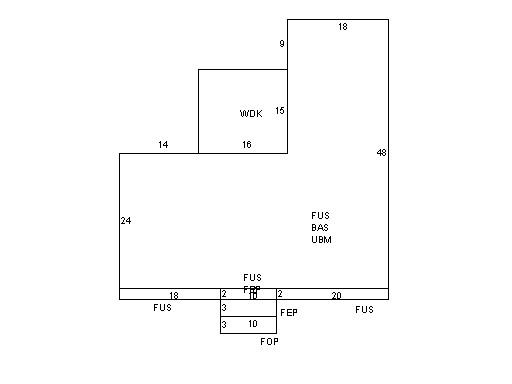
Building Description
|
|
|
| Building
Style |
Family Conv |
Foundation
Type |
|
Flooring
Type |
Softwood |
| # of Living
Units |
2 |
Frame
Type |
|
Basement
Floor |
N/A |
| Year
Built |
1971 |
Roof
Structure |
Gable/Hip |
Heating
Type |
Hot Water |
| Building
Grade |
5 1.20 |
Roof
Cover |
Asphalt |
Heating
Fuel |
Oil |
| Building
Condition |
Average |
Siding |
Wood Shingle |
Air
Conditioning |
0% |
| Finished
Area (SF) |
3264 |
Interior
Walls |
Drywall |
# of Bsmt
Garages |
0 |
| Number
Rooms |
6 |
# of
Bedrooms |
4 |
# of Full
Baths |
3 |
| # of 3/4
Baths |
0 |
# of 1/2
Baths |
0 |
# of Other
Fixtures |
0 |
|
|
|
|
| Legal Description
|
|
|
|
|
|
|
| Narrative Description of Property
|
|
|
|
This property contains 0.851 acres of land mainly classified as
TWO FAM
with a(n) Family Conv style building, built about
1971 , having Wood Shingle exterior and Asphalt
roof cover, with 2
unit(s), 6
room(s), 4
bedroom(s), 3
bath(s), 0 half bath(s). |
|
|
|
| Property Images
|
|
|