|
Unofficial Property Record Card - Falmouth, MA
|
|

|
|
General Property Data
|
|
|
| Parcel
ID |
46B 03 005 002 |
Account
Number |
FALMOUTH HEIGHTS |
| Prior Parcel
ID |
-- |
| Property
Owner |
LEONARDI MARGARET A |
Property
Location |
10 VERNON AVE |
| |
|
Property
Use |
ONE FAMILY |
| Mailing
Address |
10 VERNON AVE |
Most
Recent
Sale Date |
11/17/2020 |
| |
|
Legal
Reference |
33478-59 |
| City |
FALMOUTH |
Grantor |
LEONARDI,LOIS ANN B |
| Mailing
State |
|
Sale Price |
100 |
| ParcelZoning |
RC |
Land Area |
0.296 acres |
|
|
|
|
|
Current Property Assessment
|
|
|
| Card 1 Value |
Building Value |
404,800 |
Xtra Features Value |
900 |
Land Value |
1,220,300 |
Total Value |
1,626,000 |
|
Total Parcel Value |
Building Value |
404,800 |
Xtra Features Value |
900 |
Land Value |
1,220,300 |
Total Value |
1,626,000 |
|
|
|
|
|
| Legal Description
|
|
|
|
|
|
|
| Narrative Description of Property
|
|
|
|
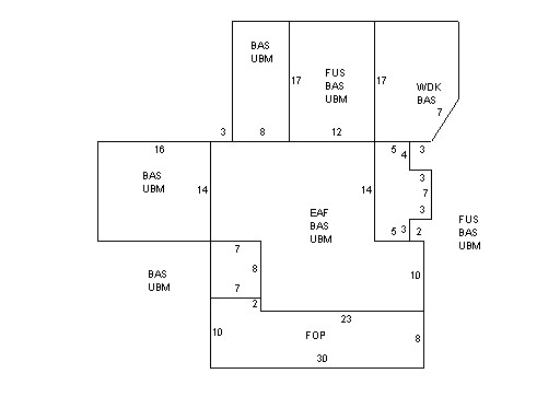
This property contains 0.296 acres of land mainly classified as
ONE FAMILY
with a(n) Conventional style building, built about
1910 , having Wood Shingle exterior and Asphalt
roof cover, with 1
unit(s), 7
room(s), 4
bedroom(s), 1
bath(s), 0 half bath(s). |
|