|
Unofficial Property Record Card - Falmouth, MA
|
|

|
|
General Property Data
|
|
|
| Parcel
ID |
46B 09 002 001 |
Account
Number |
FALMOUTH HEIGHTS |
| Prior Parcel
ID |
-- |
| Property
Owner |
HARVEY GERALD |
Property
Location |
3 QUINAPOXET AVE |
| |
HARVEY MAURA |
Property
Use |
ONE FAMILY |
| Mailing
Address |
137 FOSTER ST |
Most
Recent
Sale Date |
6/21/2019 |
| |
|
Legal
Reference |
32105-331 |
| City |
BRIGHTON |
Grantor |
COONEY,THOMAS W |
| Mailing
State |
|
Sale Price |
710,000 |
| ParcelZoning |
RC |
Land Area |
0.152 acres |
|
|
|
|
|
Current Property Assessment
|
|
|
| Card 1 Value |
Building Value |
322,300 |
Xtra Features Value |
1,100 |
Land Value |
535,300 |
Total Value |
858,700 |
|
Total Parcel Value |
Building Value |
322,300 |
Xtra Features Value |
1,100 |
Land Value |
535,300 |
Total Value |
858,700 |
|
|
|
|
|
|
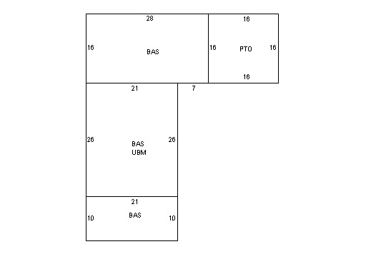
Building Description
|
|
|
| Building
Style |
Ranch |
Foundation
Type |
|
Flooring
Type |
Hardwood |
| # of Living
Units |
1 |
Frame
Type |
Wood |
Basement
Floor |
N/A |
| Year
Built |
1920 |
Roof
Structure |
Gable/Hip |
Heating
Type |
Hot Water |
| Building
Grade |
6 1.35 |
Roof
Cover |
Tile |
Heating
Fuel |
Gas |
| Building
Condition |
Average |
Siding |
CB Stucco |
Air
Conditioning |
100% |
| Finished
Area (SF) |
1204 |
Interior
Walls |
Plaster |
# of Bsmt
Garages |
0 |
| Number
Rooms |
6 |
# of
Bedrooms |
3 |
# of Full
Baths |
0 |
| # of 3/4
Baths |
2 |
# of 1/2
Baths |
0 |
# of Other
Fixtures |
0 |
|
|
|
|
| Legal Description
|
|
|
|
FY13 MERGED BY ASSESSORS WITH 46B09 003 000A PLAN FOR LOT A 642/23
|
|
|
| Narrative Description of Property
|
|
|
|
This property contains 0.152 acres of land mainly classified as
ONE FAMILY
with a(n) Ranch style building, built about
1920 , having CB Stucco exterior and Tile
roof cover, with 1
unit(s), 6
room(s), 3
bedroom(s), 0
bath(s), 0 half bath(s). |
|
|
|
| Property Images
|
|
|