|
Unofficial Property Record Card - Falmouth, MA
|
|

|
|
General Property Data
|
|
|
| Parcel
ID |
46B 28 004 022 |
Account
Number |
FALMOUTH HEIGHTS |
| Prior Parcel
ID |
-- |
| Property
Owner |
SOREM LUCIA J |
Property
Location |
22 AMHERST AVE |
| |
KELLEY DAVID |
Property
Use |
MULT HS |
| Mailing
Address |
22 AMHERST AVE |
Most
Recent
Sale Date |
9/10/1980 |
| |
|
Legal
Reference |
03151-0112 |
| City |
FALMOUTH |
Grantor |
|
| Mailing
State |
|
Sale Price |
62,700 |
| ParcelZoning |
RC |
Land Area |
0.128 acres |
|
|
|
|
|
Current Property Assessment
|
|
|
| Card 1 Value |
Building Value |
279,500 |
Xtra Features Value |
800 |
Land Value |
475,200 |
Total Value |
755,500 |
|
Total Parcel Value |
Building Value |
375,800 |
Xtra Features Value |
800 |
Land Value |
475,200 |
Total Value |
851,800 |
|
|
|
|
|
|
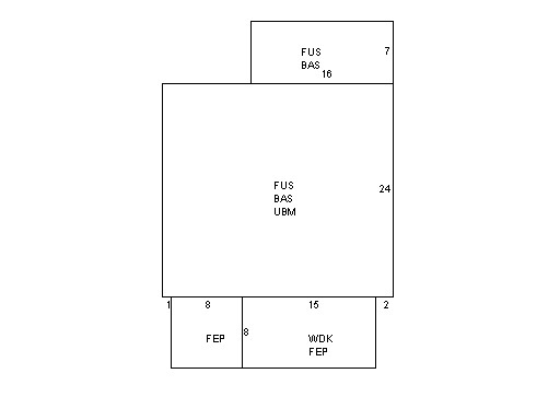
Building Description
|
|
|
| Building
Style |
Colonial |
Foundation
Type |
Conc Block |
Flooring
Type |
Hardwood |
| # of Living
Units |
0 |
Frame
Type |
Wood |
Basement
Floor |
N/A |
| Year
Built |
1925 |
Roof
Structure |
Gable/Hip |
Heating
Type |
Frcd Hot Air |
| Building
Grade |
6 1.35 |
Roof
Cover |
Asphalt |
Heating
Fuel |
Gas |
| Building
Condition |
Average |
Siding |
Wood Shingle |
Air
Conditioning |
0% |
| Finished
Area (SF) |
1472 |
Interior
Walls |
Plaster |
# of Bsmt
Garages |
0 |
| Number
Rooms |
6 |
# of
Bedrooms |
3 |
# of Full
Baths |
1 |
| # of 3/4
Baths |
0 |
# of 1/2
Baths |
1 |
# of Other
Fixtures |
0 |
|
|
|
|
| Legal Description
|
|
|
|
|
|
|
| Narrative Description of Property
|
|
|
|
This property contains 0.128 acres of land mainly classified as
MULT HS
with a(n) Colonial style building, built about
1925 , having Wood Shingle exterior and Asphalt
roof cover, with 0
unit(s), 6
room(s), 3
bedroom(s), 1
bath(s), 1 half bath(s). |
|
|
|
| Property Images
|
|
|