|
Unofficial Property Record Card - Falmouth, MA
|
|

|
|
General Property Data
|
|
|
| Parcel
ID |
47 01 009 002 |
Account
Number |
Falmouth |
| Prior Parcel
ID |
-- |
| Property
Owner |
SAUNDERS MORTON T |
Property
Location |
216 ELM RD |
| |
|
Property
Use |
ONE FAMILY |
| Mailing
Address |
4504 BRIAR HILL WEST |
Most
Recent
Sale Date |
1/1/1972 |
| |
|
Legal
Reference |
00446-6300 |
| City |
LAFAYETTE HILL |
Grantor |
|
| Mailing
State |
|
Sale Price |
0 |
| ParcelZoning |
RB |
Land Area |
0.528 acres |
|
|
|
|
|
Current Property Assessment
|
|
|
| Card 1 Value |
Building Value |
465,800 |
Xtra Features Value |
13,400 |
Land Value |
413,600 |
Total Value |
892,800 |
|
Total Parcel Value |
Building Value |
465,800 |
Xtra Features Value |
13,400 |
Land Value |
413,600 |
Total Value |
892,800 |
|
|
|
|
|
|
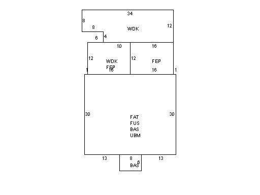
Building Description
|
|
|
| Building
Style |
Colonial |
Foundation
Type |
Stone |
Flooring
Type |
Softwood |
| # of Living
Units |
1 |
Frame
Type |
Wood |
Basement
Floor |
N/A |
| Year
Built |
1917 |
Roof
Structure |
Gable/Hip |
Heating
Type |
Hot Water |
| Building
Grade |
6 1.35 |
Roof
Cover |
WoodShingle |
Heating
Fuel |
Oil |
| Building
Condition |
Average |
Siding |
Wood Shingle |
Air
Conditioning |
100% |
| Finished
Area (SF) |
2598 |
Interior
Walls |
Plaster |
# of Bsmt
Garages |
0 |
| Number
Rooms |
8 |
# of
Bedrooms |
5 |
# of Full
Baths |
2 |
| # of 3/4
Baths |
0 |
# of 1/2
Baths |
1 |
# of Other
Fixtures |
0 |
|
|
|
|
| Legal Description
|
|
|
|
|
|
|
| Narrative Description of Property
|
|
|
|
This property contains 0.528 acres of land mainly classified as
ONE FAMILY
with a(n) Colonial style building, built about
1917 , having Wood Shingle exterior and WoodShingle
roof cover, with 1
unit(s), 8
room(s), 5
bedroom(s), 2
bath(s), 1 half bath(s). |
|
|
|
| Property Images
|
|
|