|
Unofficial Property Record Card - Falmouth, MA
|
|

|
|
General Property Data
|
|
|
| Parcel
ID |
47 03 068 003A |
Account
Number |
Falmouth |
| Prior Parcel
ID |
-- |
| Property
Owner |
SMITH PAUL C |
Property
Location |
310 MILL RD |
| |
SMITH SANDRA M |
Property
Use |
ONE FAMILY |
| Mailing
Address |
310 MILL RD |
Most
Recent
Sale Date |
11/10/2010 |
| |
|
Legal
Reference |
192901 |
| City |
FALMOUTH |
Grantor |
SMITH,PAUL C |
| Mailing
State |
|
Sale Price |
1 |
| ParcelZoning |
RC |
Land Area |
1.208 acres |
|
|
|
|
|
Current Property Assessment
|
|
|
| Card 1 Value |
Building Value |
729,800 |
Xtra Features Value |
5,900 |
Land Value |
905,500 |
Total Value |
1,641,200 |
|
Total Parcel Value |
Building Value |
729,800 |
Xtra Features Value |
5,900 |
Land Value |
905,500 |
Total Value |
1,641,200 |
|
|
|
|
|
| Legal Description
|
|
|
|
|
|
|
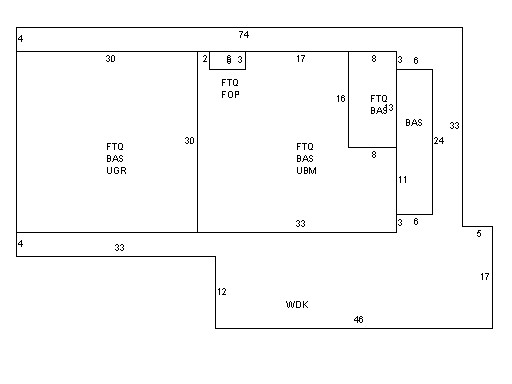
| Narrative Description of Property
|
|
|
|
This property contains 1.208 acres of land mainly classified as
ONE FAMILY
with a(n) Gambrel style building, built about
1880 , having Wood Shingle exterior and Asphalt
roof cover, with 1
unit(s), 6
room(s), 3
bedroom(s), 2
bath(s), 1 half bath(s). |
|