|
Unofficial Property Record Card - Falmouth, MA
|
|

|
|
General Property Data
|
|
|
| Parcel
ID |
47 06 018 011 |
Account
Number |
Falmouth |
| Prior Parcel
ID |
-- |
| Property
Owner |
FORANCE MICHAEL D |
Property
Location |
14 THOMAS CIR |
| |
FORANCE MARY ELIZABETH |
Property
Use |
TWO FAM |
| Mailing
Address |
557 OCEAN ST |
Most
Recent
Sale Date |
4/4/2012 |
| |
|
Legal
Reference |
26219-225 |
| City |
HYANNIS |
Grantor |
FORANCE TRUSTEE,MICHAEL |
| Mailing
State |
|
Sale Price |
100 |
| ParcelZoning |
RC |
Land Area |
0.253 acres |
|
|
|
|
|
Current Property Assessment
|
|
|
| Card 1 Value |
Building Value |
214,000 |
Xtra Features Value |
0 |
Land Value |
507,700 |
Total Value |
721,700 |
|
Total Parcel Value |
Building Value |
214,000 |
Xtra Features Value |
0 |
Land Value |
507,700 |
Total Value |
721,700 |
|
|
|
|
|
|
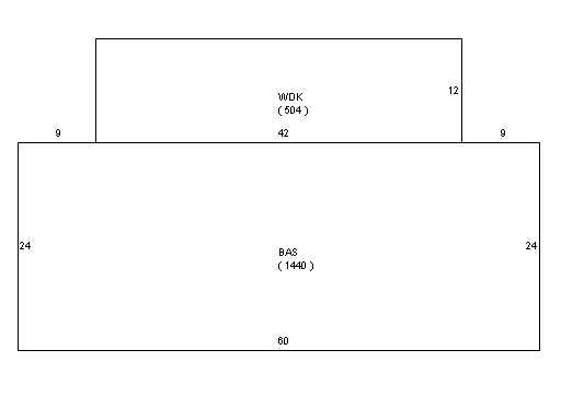
Building Description
|
|
|
| Building
Style |
Family Duplx |
Foundation
Type |
|
Flooring
Type |
Softwood |
| # of Living
Units |
2 |
Frame
Type |
|
Basement
Floor |
N/A |
| Year
Built |
1958 |
Roof
Structure |
Gable/Hip |
Heating
Type |
Frcd Hot Air |
| Building
Grade |
4 1.1 |
Roof
Cover |
Asphalt |
Heating
Fuel |
Gas |
| Building
Condition |
Average |
Siding |
Wood Shingle |
Air
Conditioning |
0% |
| Finished
Area (SF) |
1440 |
Interior
Walls |
Drywall |
# of Bsmt
Garages |
0 |
| Number
Rooms |
6 |
# of
Bedrooms |
4 |
# of Full
Baths |
2 |
| # of 3/4
Baths |
0 |
# of 1/2
Baths |
0 |
# of Other
Fixtures |
0 |
|
|
|
|
| Legal Description
|
|
|
|
|
|
|
| Narrative Description of Property
|
|
|
|
This property contains 0.253 acres of land mainly classified as
TWO FAM
with a(n) Family Duplx style building, built about
1958 , having Wood Shingle exterior and Asphalt
roof cover, with 2
unit(s), 6
room(s), 4
bedroom(s), 2
bath(s), 0 half bath(s). |
|
|
|
| Property Images
|
|
|