|
Unofficial Property Record Card - Falmouth, MA
|
|

|
|
General Property Data
|
|
|
| Parcel
ID |
47 06 018 015 |
Account
Number |
Falmouth |
| Prior Parcel
ID |
-- |
| Property
Owner |
STEEVES III FREDERICK R |
Property
Location |
26 THOMAS CIR |
| |
STEEVES NATALIE T |
Property
Use |
TWO FAM |
| Mailing
Address |
26 THOMAS CIR |
Most
Recent
Sale Date |
6/24/1992 |
| |
|
Legal
Reference |
08081-0144 |
| City |
FALMOUTH |
Grantor |
WALKEY EDWIN A ETAL |
| Mailing
State |
|
Sale Price |
114,300 |
| ParcelZoning |
RC |
Land Area |
0.238 acres |
|
|
|
|
|
Current Property Assessment
|
|
|
| Card 1 Value |
Building Value |
664,800 |
Xtra Features Value |
0 |
Land Value |
503,700 |
Total Value |
1,168,500 |
|
Total Parcel Value |
Building Value |
664,800 |
Xtra Features Value |
0 |
Land Value |
503,700 |
Total Value |
1,168,500 |
|
|
|
|
|
|
Building Description
|
|
|
| Building
Style |
Conventional |
Foundation
Type |
|
Flooring
Type |
Softwood |
| # of Living
Units |
2 |
Frame
Type |
|
Basement
Floor |
N/A |
| Year
Built |
2019 |
Roof
Structure |
Gable/Hip |
Heating
Type |
Frcd Hot Air |
| Building
Grade |
6 1.35 |
Roof
Cover |
Asphalt |
Heating
Fuel |
Gas |
| Building
Condition |
Average |
Siding |
Wood Shingle |
Air
Conditioning |
100% |
| Finished
Area (SF) |
2472 |
Interior
Walls |
Drywall |
# of Bsmt
Garages |
0 |
| Number
Rooms |
9 |
# of
Bedrooms |
5 |
# of Full
Baths |
2 |
| # of 3/4
Baths |
1 |
# of 1/2
Baths |
1 |
# of Other
Fixtures |
2 |
|
|
|
|
| Legal Description
|
|
|
|
|
|
|
| Narrative Description of Property
|
|
|
|
This property contains 0.238 acres of land mainly classified as
TWO FAM
with a(n) Conventional style building, built about
2019 , having Wood Shingle exterior and Asphalt
roof cover, with 2
unit(s), 9
room(s), 5
bedroom(s), 2
bath(s), 1 half bath(s). |
|
|
|
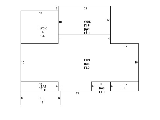
| Property Images
|
|
|