|
Unofficial Property Record Card - Falmouth, MA
|
|

|
|
General Property Data
|
|
|
| Parcel
ID |
47 07 018 006F |
Account
Number |
Falmouth |
| Prior Parcel
ID |
-- |
| Property
Owner |
MCGOWAN TRUSTEE MICHAEL D |
Property
Location |
338 SURF DR |
| |
FARMER TRUSTEE MARY M |
Property
Use |
ONE FAMILY |
| Mailing
Address |
121 LOCUST ST |
Most
Recent
Sale Date |
6/18/2007 |
| |
|
Legal
Reference |
183394 |
| City |
FALMOUTH |
Grantor |
FARMER,MARY M |
| Mailing
State |
|
Sale Price |
100 |
| ParcelZoning |
RB |
Land Area |
0.129 acres |
|
|
|
|
|
Current Property Assessment
|
|
|
| Card 1 Value |
Building Value |
102,000 |
Xtra Features Value |
0 |
Land Value |
475,400 |
Total Value |
577,400 |
|
Total Parcel Value |
Building Value |
102,000 |
Xtra Features Value |
0 |
Land Value |
475,400 |
Total Value |
577,400 |
|
|
|
|
|
|
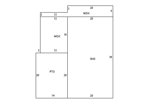
Building Description
|
|
|
| Building
Style |
Bungalow |
Foundation
Type |
|
Flooring
Type |
Softwood |
| # of Living
Units |
1 |
Frame
Type |
Wood |
Basement
Floor |
N/A |
| Year
Built |
1945 |
Roof
Structure |
Gable/Hip |
Heating
Type |
None |
| Building
Grade |
3 1.0 |
Roof
Cover |
Asphalt |
Heating
Fuel |
NONE |
| Building
Condition |
Average |
Siding |
Wood Shingle |
Air
Conditioning |
0% |
| Finished
Area (SF) |
720 |
Interior
Walls |
Drywall |
# of Bsmt
Garages |
0 |
| Number
Rooms |
3 |
# of
Bedrooms |
1 |
# of Full
Baths |
1 |
| # of 3/4
Baths |
0 |
# of 1/2
Baths |
0 |
# of Other
Fixtures |
1 |
|
|
|
|
| Legal Description
|
|
|
|
|
|
|
| Narrative Description of Property
|
|
|
|
This property contains 0.129 acres of land mainly classified as
ONE FAMILY
with a(n) Bungalow style building, built about
1945 , having Wood Shingle exterior and Asphalt
roof cover, with 1
unit(s), 3
room(s), 1
bedroom(s), 1
bath(s), 0 half bath(s). |
|
|
|
| Property Images
|
|
|