|
Unofficial Property Record Card - Falmouth, MA
|
|

|
|
General Property Data
|
|
|
| Parcel
ID |
47A 03 064B 004 |
Account
Number |
Falmouth |
| Prior Parcel
ID |
CANOPY -- |
| Property
Owner |
HATEM TRUSTEE JOHNNY |
Property
Location |
10 NORTH MAIN ST |
| |
HATEM ENTERPRISES NOM TRUST |
Property
Use |
SERV STA |
| Mailing
Address |
561 THOMAS B LANDERS RD |
Most
Recent
Sale Date |
1/23/2003 |
| |
|
Legal
Reference |
16284-0347 |
| City |
EAST FALMOUTH |
Grantor |
GULF OIL LIMITED PARTNERSHIP |
| Mailing
State |
|
Sale Price |
550,000 |
| ParcelZoning |
B2 |
Land Area |
0.344 acres |
|
|
|
|
|
Current Property Assessment
|
|
|
| Card 1 Value |
Building Value |
230,800 |
Xtra Features Value |
267,400 |
Land Value |
431,300 |
Total Value |
929,500 |
|
Total Parcel Value |
Building Value |
230,800 |
Xtra Features Value |
267,400 |
Land Value |
431,300 |
Total Value |
929,500 |
|
|
|
|
|
|
Building Description
|
|
|
| Building
Style |
ServSta 2Bay |
Foundation
Type |
|
Flooring
Type |
Conc Slab |
| # of Living
Units |
1 |
Frame
Type |
Masonry |
Basement
Floor |
N/A |
| Year
Built |
1968 |
Roof
Structure |
Gable/Hip |
Heating
Type |
Frcd Hot Air |
| Building
Grade |
5 1.20 |
Roof
Cover |
Asphalt |
Heating
Fuel |
Oil |
| Building
Condition |
Average |
Siding |
Brick Veneer |
Air
Conditioning |
0% |
| Finished
Area (SF) |
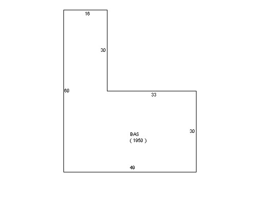
1950 |
Interior
Walls |
Minimum |
# of Bsmt
Garages |
0 |
| Number
Rooms |
0 |
# of
Bedrooms |
0 |
# of Full
Baths |
0 |
| # of 3/4
Baths |
0 |
# of 1/2
Baths |
0 |
# of Other
Fixtures |
0 |
|
|
|
|
| Legal Description
|
|
|
|
|
|
|
| Narrative Description of Property
|
|
|
|
This property contains 0.344 acres of land mainly classified as
SERV STA
with a(n) ServSta 2Bay style building, built about
1968 , having Brick Veneer exterior and Asphalt
roof cover, with 1
unit(s), 0
room(s), 0
bedroom(s), 0
bath(s), 0 half bath(s). |
|
|
|
| Property Images
|
|
|