|
Unofficial Property Record Card - Falmouth, MA
|
|

|
|
General Property Data
|
|
|
| Parcel
ID |
47A 07 067A 002 |
Account
Number |
Falmouth |
| Prior Parcel
ID |
-- |
| Property
Owner |
PARISH OF SAINT BARNABAS |
Property
Location |
135 MAIN ST |
| |
|
Property
Use |
RECTORY |
| Mailing
Address |
97 MAIN ST |
Most
Recent
Sale Date |
1/1/1900 |
| |
|
Legal
Reference |
12890-3610 |
| City |
FALMOUTH |
Grantor |
|
| Mailing
State |
|
Sale Price |
0 |
| ParcelZoning |
GR |
Land Area |
0.239 acres |
|
|
|
|
|
Current Property Assessment
|
|
|
| Card 1 Value |
Building Value |
308,800 |
Xtra Features Value |
0 |
Land Value |
296,500 |
Total Value |
605,300 |
|
Total Parcel Value |
Building Value |
308,800 |
Xtra Features Value |
0 |
Land Value |
296,500 |
Total Value |
605,300 |
|
|
|
|
|
|
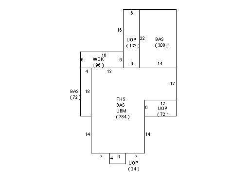
Building Description
|
|
|
| Building
Style |
Conventional |
Foundation
Type |
|
Flooring
Type |
Softwood |
| # of Living
Units |
0 |
Frame
Type |
|
Basement
Floor |
N/A |
| Year
Built |
1920 |
Roof
Structure |
Gable/Hip |
Heating
Type |
Hot Water |
| Building
Grade |
7 1.5 |
Roof
Cover |
Asphalt |
Heating
Fuel |
Oil |
| Building
Condition |
Average |
Siding |
Wood on Shth |
Air
Conditioning |
0% |
| Finished
Area (SF) |
1752 |
Interior
Walls |
Drywall |
# of Bsmt
Garages |
0 |
| Number
Rooms |
0 |
# of
Bedrooms |
0 |
# of Full
Baths |
2 |
| # of 3/4
Baths |
0 |
# of 1/2
Baths |
0 |
# of Other
Fixtures |
0 |
|
|
|
|
| Legal Description
|
|
|
|
|
|
|
| Narrative Description of Property
|
|
|
|
This property contains 0.239 acres of land mainly classified as
RECTORY
with a(n) Conventional style building, built about
1920 , having Wood on Shth exterior and Asphalt
roof cover, with 0
unit(s), 0
room(s), 0
bedroom(s), 2
bath(s), 0 half bath(s). |
|
|
|
| Property Images
|
|
|