|
Unofficial Property Record Card - Falmouth, MA
|
|

|
|
General Property Data
|
|
|
| Parcel
ID |
47B 03 017A 004 |
Account
Number |
Falmouth |
| Prior Parcel
ID |
-- |
| Property
Owner |
FAY JR TR ETAL JOHN J |
Property
Location |
4 LANTERN LN |
| |
FAYS REALTY TRUST |
Property
Use |
COM WHS |
| Mailing
Address |
12 CANAPITSIT DR |
Most
Recent
Sale Date |
1/1/1974 |
| |
|
Legal
Reference |
01990-0352 |
| City |
E FALMOUTH |
Grantor |
|
| Mailing
State |
|
Sale Price |
0 |
| ParcelZoning |
BR |
Land Area |
0.735 acres |
|
|
|
|
|
Current Property Assessment
|
|
|
| Card 1 Value |
Building Value |
151,000 |
Xtra Features Value |
0 |
Land Value |
352,200 |
Total Value |
503,200 |
|
Total Parcel Value |
Building Value |
151,000 |
Xtra Features Value |
0 |
Land Value |
352,200 |
Total Value |
503,200 |
|
|
|
|
|
|
Building Description
|
|
|
| Building
Style |
Warehousing |
Foundation
Type |
|
Flooring
Type |
Conc Slab |
| # of Living
Units |
1 |
Frame
Type |
Wood |
Basement
Floor |
N/A |
| Year
Built |
1944 |
Roof
Structure |
Gable/Hip |
Heating
Type |
Frcd Hot Air |
| Building
Grade |
3 1.0 |
Roof
Cover |
Asphalt |
Heating
Fuel |
Oil |
| Building
Condition |
Average |
Siding |
Below Av |
Air
Conditioning |
0% |
| Finished
Area (SF) |
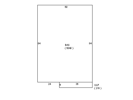
5040 |
Interior
Walls |
Minimum |
# of Bsmt
Garages |
0 |
| Number
Rooms |
0 |
# of
Bedrooms |
0 |
# of Full
Baths |
0 |
| # of 3/4
Baths |
0 |
# of 1/2
Baths |
0 |
# of Other
Fixtures |
0 |
|
|
|
|
| Legal Description
|
|
|
|
|
|
|
| Narrative Description of Property
|
|
|
|
This property contains 0.735 acres of land mainly classified as
COM WHS
with a(n) Warehousing style building, built about
1944 , having Below Av exterior and Asphalt
roof cover, with 1
unit(s), 0
room(s), 0
bedroom(s), 0
bath(s), 0 half bath(s). |
|
|
|
| Property Images
|
|
|