|
Unofficial Property Record Card - Falmouth, MA
|
|

|
|
General Property Data
|
|
|
| Parcel
ID |
47B 06 018 000 |
Account
Number |
Falmouth |
| Prior Parcel
ID |
-- |
| Property
Owner |
PERSON MATTHEW A |
Property
Location |
21 TAYLOR CT |
| |
ERICKSON JILL E |
Property
Use |
TWO FAM |
| Mailing
Address |
21 TAYLOR CT |
Most
Recent
Sale Date |
9/23/2019 |
| |
|
Legal
Reference |
32317-260 |
| City |
FALMOUTH |
Grantor |
HOSOM,DAVID S |
| Mailing
State |
|
Sale Price |
450,000 |
| ParcelZoning |
GR |
Land Area |
0.188 acres |
|
|
|
|
|
Current Property Assessment
|
|
|
| Card 1 Value |
Building Value |
210,000 |
Xtra Features Value |
9,500 |
Land Value |
267,000 |
Total Value |
486,500 |
|
Total Parcel Value |
Building Value |
210,000 |
Xtra Features Value |
9,500 |
Land Value |
267,000 |
Total Value |
486,500 |
|
|
|
|
|
|
Building Description
|
|
|
| Building
Style |
Family Conv |
Foundation
Type |
|
Flooring
Type |
Hardwood |
| # of Living
Units |
2 |
Frame
Type |
Wood |
Basement
Floor |
N/A |
| Year
Built |
1920 |
Roof
Structure |
Gable/Hip |
Heating
Type |
Hot Water |
| Building
Grade |
4 1.1 |
Roof
Cover |
Asphalt |
Heating
Fuel |
Gas |
| Building
Condition |
Average |
Siding |
Vinyl Siding |
Air
Conditioning |
0% |
| Finished
Area (SF) |
1592 |
Interior
Walls |
Drywall |
# of Bsmt
Garages |
0 |
| Number
Rooms |
7 |
# of
Bedrooms |
2 |
# of Full
Baths |
2 |
| # of 3/4
Baths |
0 |
# of 1/2
Baths |
0 |
# of Other
Fixtures |
0 |
|
|
|
|
| Legal Description
|
|
|
|
|
|
|
| Narrative Description of Property
|
|
|
|
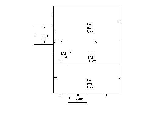
This property contains 0.188 acres of land mainly classified as
TWO FAM
with a(n) Family Conv style building, built about
1920 , having Vinyl Siding exterior and Asphalt
roof cover, with 2
unit(s), 7
room(s), 2
bedroom(s), 2
bath(s), 0 half bath(s). |
|
|
|
| Property Images
|
|
|