|
Unofficial Property Record Card - Falmouth, MA
|
|

|
|
General Property Data
|
|
|
| Parcel
ID |
47B 09 009 009C |
Account
Number |
Falmouth |
| Prior Parcel
ID |
FLOORING -- |
| Property
Owner |
SCRANTON LLC |
Property
Location |
32 SCRANTON AVE |
| |
|
Property
Use |
STORE |
| Mailing
Address |
115 ASSOCIATES RD |
Most
Recent
Sale Date |
6/29/2022 |
| |
|
Legal
Reference |
230385 |
| City |
FALMOUTH |
Grantor |
DERICK TRUSTEE,MARTHA L |
| Mailing
State |
|
Sale Price |
1,650,000 |
| ParcelZoning |
B2 |
Land Area |
0.399 acres |
|
|
|
|
|
Current Property Assessment
|
|
|
| Card 1 Value |
Building Value |
183,800 |
Xtra Features Value |
11,000 |
Land Value |
447,500 |
Total Value |
642,300 |
|
Total Parcel Value |
Building Value |
183,800 |
Xtra Features Value |
11,000 |
Land Value |
447,500 |
Total Value |
642,300 |
|
|
|
|
|
| Legal Description
|
|
|
|
|
|
|
| Narrative Description of Property
|
|
|
|
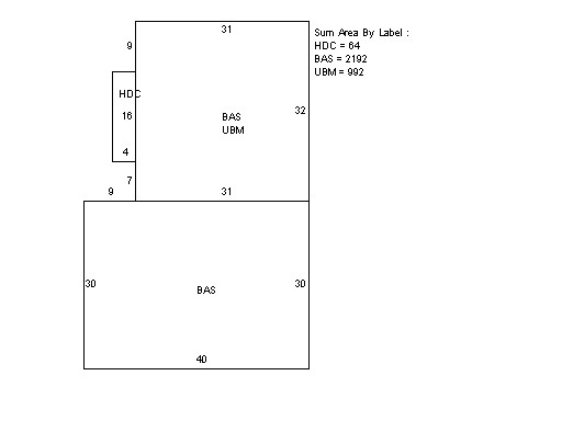
This property contains 0.399 acres of land mainly classified as
STORE
with a(n) Dry Cleaner style building, built about
1950 , having Wood Shingle exterior and Asphalt
roof cover, with 1
unit(s), 0
room(s), 0
bedroom(s), 0
bath(s), 0 half bath(s). |
|