|
Unofficial Property Record Card - Falmouth, MA
|
|

|
|
General Property Data
|
|
|
| Parcel
ID |
47C 03 021 038 |
Account
Number |
Falmouth |
| Prior Parcel
ID |
-- |
| Property
Owner |
DEMITA JOSEPH V |
Property
Location |
20 RICHARDS RD |
| |
DEMITA KATHLEEN F |
Property
Use |
ONE FAMILY |
| Mailing
Address |
119 LILAH LN |
Most
Recent
Sale Date |
12/16/2009 |
| |
|
Legal
Reference |
190318 |
| City |
READING |
Grantor |
WATSON TRUSTEE,NANCY L |
| Mailing
State |
|
Sale Price |
850,000 |
| ParcelZoning |
RC |
Land Area |
0.735 acres |
|
|
|
|
|
Current Property Assessment
|
|
|
| Card 1 Value |
Building Value |
699,200 |
Xtra Features Value |
49,900 |
Land Value |
526,400 |
Total Value |
1,275,500 |
|
Total Parcel Value |
Building Value |
699,200 |
Xtra Features Value |
49,900 |
Land Value |
526,400 |
Total Value |
1,275,500 |
|
|
|
|
|
| Legal Description
|
|
|
|
|
|
|
| Narrative Description of Property
|
|
|
|
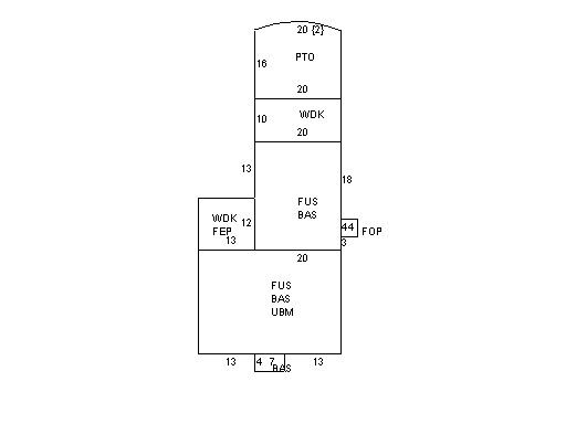
This property contains 0.735 acres of land mainly classified as
ONE FAMILY
with a(n) Colonial style building, built about
1940 , having Wood Shingle exterior and Asphalt
roof cover, with 1
unit(s), 8
room(s), 5
bedroom(s), 2
bath(s), 2 half bath(s). |
|