|
Unofficial Property Record Card - Falmouth, MA
|
|

|
|
General Property Data
|
|
|
| Parcel
ID |
47C 06 003 000 |
Account
Number |
Falmouth |
| Prior Parcel
ID |
ROOF -- |
| Property
Owner |
MITCHELL TRUSTEE JOHN D |
Property
Location |
340 SCRANTON AVE |
| |
SOLON TRUSTEE JOHN S |
Property
Use |
ONE FAMILY |
| Mailing
Address |
465 WARREN ST |
Most
Recent
Sale Date |
7/21/2022 |
| |
|
Legal
Reference |
35262-200 |
| City |
BROOKLINE |
Grantor |
MITCHELL,JOHN D |
| Mailing
State |
|
Sale Price |
1 |
| ParcelZoning |
RC |
Land Area |
0.179 acres |
|
|
|
|
|
Current Property Assessment
|
|
|
| Card 1 Value |
Building Value |
1,628,400 |
Xtra Features Value |
147,100 |
Land Value |
1,723,800 |
Total Value |
3,499,300 |
|
Total Parcel Value |
Building Value |
1,628,400 |
Xtra Features Value |
147,100 |
Land Value |
1,723,800 |
Total Value |
3,499,300 |
|
|
|
|
|
| Legal Description
|
|
|
|
|
|
|
| Narrative Description of Property
|
|
|
|
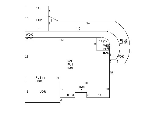
This property contains 0.179 acres of land mainly classified as
ONE FAMILY
with a(n) Custom style building, built about
1991 , having Wood Shingle exterior and WoodShingle
roof cover, with 1
unit(s), 6
room(s), 3
bedroom(s), 4
bath(s), 1 half bath(s). |
|