|
Unofficial Property Record Card - Falmouth, MA
|
|

|
|
General Property Data
|
|
|
| Parcel
ID |
47C 06 004 000 |
Account
Number |
Falmouth |
| Prior Parcel
ID |
ROOF -- |
| Property
Owner |
HARBORWAY CORPORATION |
Property
Location |
334 SCRANTON AVE |
| |
|
Property
Use |
ONE FAMILY |
| Mailing
Address |
60 SWING LN |
Most
Recent
Sale Date |
7/25/2002 |
| |
|
Legal
Reference |
166034 |
| City |
FALMOUTH |
Grantor |
ROBERTSON PHILIP S ETAL |
| Mailing
State |
|
Sale Price |
1,540,000 |
| ParcelZoning |
RC |
Land Area |
0.342 acres |
|
|
|
|
|
Current Property Assessment
|
|
|
| Card 1 Value |
Building Value |
230,100 |
Xtra Features Value |
134,800 |
Land Value |
1,872,500 |
Total Value |
2,237,400 |
|
Total Parcel Value |
Building Value |
230,100 |
Xtra Features Value |
134,800 |
Land Value |
1,872,500 |
Total Value |
2,237,400 |
|
|
|
|
|
| Legal Description
|
|
|
|
|
|
|
| Narrative Description of Property
|
|
|
|
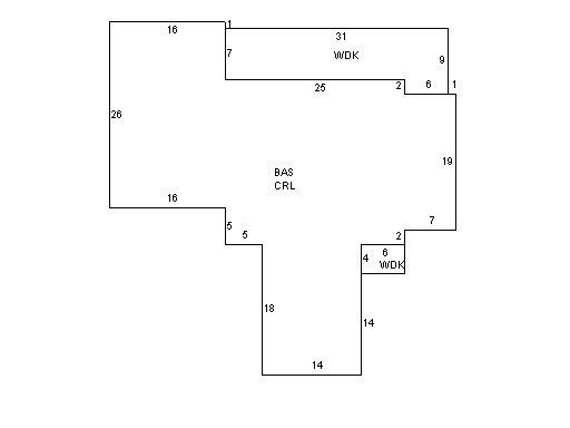
This property contains 0.342 acres of land mainly classified as
ONE FAMILY
with a(n) Ranch style building, built about
1944 , having Wood Shingle exterior and Asphalt
roof cover, with 1
unit(s), 6
room(s), 3
bedroom(s), 2
bath(s), 0 half bath(s). |
|