|
Unofficial Property Record Card - Falmouth, MA
|
|

|
|
General Property Data
|
|
|
| Parcel
ID |
48 03 003 013 |
Account
Number |
QUISSETT |
| Prior Parcel
ID |
-- |
| Property
Owner |
SMITH TRUSTEE H KERNER |
Property
Location |
29 QUISSETT HARBOR RD |
| |
29 QUISSETT REALTY TRUST |
Property
Use |
ONE FAMILY |
| Mailing
Address |
PO BOX 709 |
Most
Recent
Sale Date |
12/18/2012 |
| |
|
Legal
Reference |
199044 |
| City |
FALMOUTH |
Grantor |
SMITH,H KERNER |
| Mailing
State |
|
Sale Price |
1 |
| ParcelZoning |
RA |
Land Area |
1.303 acres |
|
|
|
|
|
Current Property Assessment
|
|
|
| Card 1 Value |
Building Value |
1,346,900 |
Xtra Features Value |
16,000 |
Land Value |
1,661,600 |
Total Value |
3,024,500 |
|
Total Parcel Value |
Building Value |
1,346,900 |
Xtra Features Value |
16,000 |
Land Value |
1,661,600 |
Total Value |
3,024,500 |
|
|
|
|
|
| Legal Description
|
|
|
|
|
|
|
| Narrative Description of Property
|
|
|
|
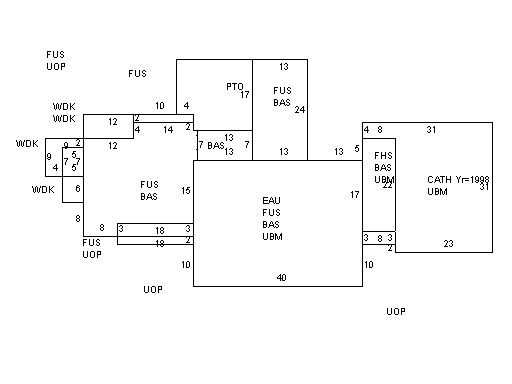
This property contains 1.303 acres of land mainly classified as
ONE FAMILY
with a(n) Colonial style building, built about
1785 , having Wood Shingle exterior and WoodShingle
roof cover, with 1
unit(s), 10
room(s), 5
bedroom(s), 4
bath(s), 1 half bath(s). |
|