|
Unofficial Property Record Card - Falmouth, MA
|
|

|
|
General Property Data
|
|
|
| Parcel
ID |
49A 05 036 024B |
Account
Number |
WOODS HOLE |
| Prior Parcel
ID |
-- |
| Property
Owner |
OLMSTED CHARLOTTE D |
Property
Location |
12 MIDDLE ST |
| |
|
Property
Use |
ONE FAMILY |
| Mailing
Address |
PO BOX 587 |
Most
Recent
Sale Date |
1/1/1973 |
| |
|
Legal
Reference |
1849-56 |
| City |
WOODS HOLE |
Grantor |
|
| Mailing
State |
|
Sale Price |
0 |
| ParcelZoning |
RC |
Land Area |
0.160 acres |
|
|
|
|
|
Current Property Assessment
|
|
|
| Card 1 Value |
Building Value |
288,200 |
Xtra Features Value |
6,000 |
Land Value |
483,400 |
Total Value |
777,600 |
|
Total Parcel Value |
Building Value |
288,200 |
Xtra Features Value |
6,000 |
Land Value |
483,400 |
Total Value |
777,600 |
|
|
|
|
|
|
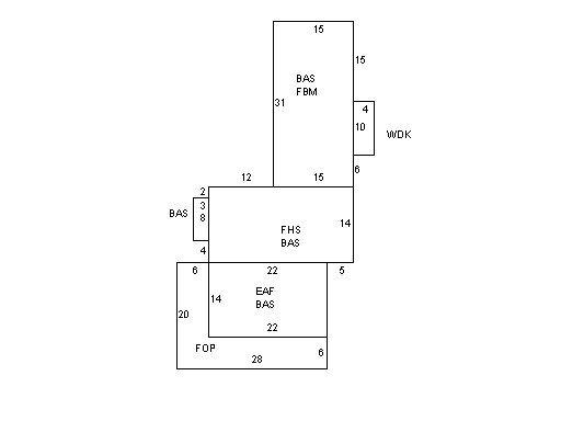
Building Description
|
|
|
| Building
Style |
Conventional |
Foundation
Type |
|
Flooring
Type |
Hardwood |
| # of Living
Units |
1 |
Frame
Type |
Wood |
Basement
Floor |
N/A |
| Year
Built |
1900 |
Roof
Structure |
Gable/Hip |
Heating
Type |
Hot Water |
| Building
Grade |
6 1.35 |
Roof
Cover |
Asphalt |
Heating
Fuel |
Gas |
| Building
Condition |
Average |
Siding |
Wood Shingle |
Air
Conditioning |
0% |
| Finished
Area (SF) |
1612.5 |
Interior
Walls |
Drywall |
# of Bsmt
Garages |
0 |
| Number
Rooms |
7 |
# of
Bedrooms |
4 |
# of Full
Baths |
2 |
| # of 3/4
Baths |
0 |
# of 1/2
Baths |
0 |
# of Other
Fixtures |
0 |
|
|
|
|
| Legal Description
|
|
|
|
|
|
|
| Narrative Description of Property
|
|
|
|
This property contains 0.160 acres of land mainly classified as
ONE FAMILY
with a(n) Conventional style building, built about
1900 , having Wood Shingle exterior and Asphalt
roof cover, with 1
unit(s), 7
room(s), 4
bedroom(s), 2
bath(s), 0 half bath(s). |
|
|
|
| Property Images
|
|
|