|
Unofficial Property Record Card - Falmouth, MA
|
|

|
|
General Property Data
|
|
|
| Parcel
ID |
46 02 006 001A |
Account
Number |
FALMOUTH |
| Prior Parcel
ID |
-- |
| Property
Owner |
53 FALMOUTH HEIGHTS LLC |
Property
Location |
57 FALMOUTH HEIGHTS RD |
| |
|
Property
Use |
STORE |
| Mailing
Address |
53 FALMOUTH HEIGHTS RD |
Most
Recent
Sale Date |
12/29/2003 |
| |
|
Legal
Reference |
18071-93 |
| City |
FALMOUTH |
Grantor |
53 FALMOUTH HEIGHTS LLC, |
| Mailing
State |
|
Sale Price |
3,720,000 |
| ParcelZoning |
M |
Land Area |
0.526 acres |
|
|
|
|
|
Current Property Assessment
|
|
|
| Card 1 Value |
Building Value |
355,100 |
Xtra Features Value |
89,100 |
Land Value |
1,486,000 |
Total Value |
1,930,200 |
|
Total Parcel Value |
Building Value |
355,100 |
Xtra Features Value |
89,100 |
Land Value |
1,486,000 |
Total Value |
1,930,200 |
|
|
|
|
|
| Legal Description
|
|
|
|
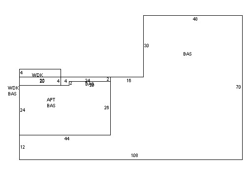
PARENT LOTS 46 02 007 001/ 46 02 006 003/ PLAN 587/75`03
|
|
|
| Narrative Description of Property
|
|
|
|
This property contains 0.526 acres of land mainly classified as
STORE
with a(n) Warehousing style building, built about
1950 , having Wood Shingle exterior and Asphalt
roof cover, with 1
unit(s), 0
room(s), 0
bedroom(s), 1
bath(s), 2 half bath(s). |
|