|
Unofficial Property Record Card - Falmouth, MA
|
|

|
|
General Property Data
|
|
|
| Parcel
ID |
40 11 009B 003 |
Account
Number |
EAST FALMOUTH |
| Prior Parcel
ID |
-- |
| Property
Owner |
ALWARDT REINHOLD J |
Property
Location |
25 ALWARDT WAY |
| |
ALWARDT MARY E |
Property
Use |
ONE FAMILY |
| Mailing
Address |
25 ALWARDT WAY |
Most
Recent
Sale Date |
1/1/1974 |
| |
|
Legal
Reference |
21030-9300 |
| City |
EAST FALMOUTH |
Grantor |
|
| Mailing
State |
|
Sale Price |
0 |
| ParcelZoning |
RC |
Land Area |
0.918 acres |
|
|
|
|
|
Current Property Assessment
|
|
|
| Card 1 Value |
Building Value |
219,900 |
Xtra Features Value |
4,200 |
Land Value |
240,000 |
Total Value |
464,100 |
|
Total Parcel Value |
Building Value |
219,900 |
Xtra Features Value |
4,200 |
Land Value |
240,000 |
Total Value |
464,100 |
|
|
|
|
|
|
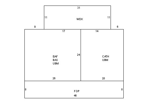
Building Description
|
|
|
| Building
Style |
Cape Cod |
Foundation
Type |
Concrete |
Flooring
Type |
Carpet |
| # of Living
Units |
1 |
Frame
Type |
Wood |
Basement
Floor |
N/A |
| Year
Built |
1990 |
Roof
Structure |
Gable/Hip |
Heating
Type |
Elec BB |
| Building
Grade |
3 1.0 |
Roof
Cover |
Asphalt |
Heating
Fuel |
Electric |
| Building
Condition |
Average |
Siding |
Logs |
Air
Conditioning |
0% |
| Finished
Area (SF) |
1416 |
Interior
Walls |
LOGS |
# of Bsmt
Garages |
0 |
| Number
Rooms |
6 |
# of
Bedrooms |
3 |
# of Full
Baths |
1 |
| # of 3/4
Baths |
1 |
# of 1/2
Baths |
0 |
# of Other
Fixtures |
1 |
|
|
|
|
| Legal Description
|
|
|
|
PARENT LOTS 40 11 009C 001 & 40 11 009B 002 / 591/98`04
|
|
|
| Narrative Description of Property
|
|
|
|
This property contains 0.918 acres of land mainly classified as
ONE FAMILY
with a(n) Cape Cod style building, built about
1990 , having Logs exterior and Asphalt
roof cover, with 1
unit(s), 6
room(s), 3
bedroom(s), 1
bath(s), 0 half bath(s). |
|
|
|
| Property Images
|
|
|