|
Unofficial Property Record Card - Falmouth, MA
|
|

|
|
General Property Data
|
|
|
| Parcel
ID |
47A 06 082A 005 |
Account
Number |
Falmouth |
| Prior Parcel
ID |
-- |
| Property
Owner |
JONES BARBARA W |
Property
Location |
38 LOCUST ST |
| |
|
Property
Use |
ONE FAMILY |
| Mailing
Address |
38 LOCUST ST |
Most
Recent
Sale Date |
6/29/1971 |
| |
|
Legal
Reference |
04130-1110 |
| City |
FALMOUTH |
Grantor |
|
| Mailing
State |
|
Sale Price |
0 |
| ParcelZoning |
GR |
Land Area |
0.465 acres |
|
|
|
|
|
Current Property Assessment
|
|
|
| Card 1 Value |
Building Value |
453,700 |
Xtra Features Value |
0 |
Land Value |
330,900 |
Total Value |
784,600 |
|
Total Parcel Value |
Building Value |
453,700 |
Xtra Features Value |
0 |
Land Value |
330,900 |
Total Value |
784,600 |
|
|
|
|
|
|
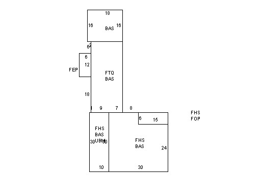
Building Description
|
|
|
| Building
Style |
Cape Cod |
Foundation
Type |
Stone |
Flooring
Type |
Softwood |
| # of Living
Units |
1 |
Frame
Type |
Wood |
Basement
Floor |
N/A |
| Year
Built |
1886 |
Roof
Structure |
Gable/Hip |
Heating
Type |
Frcd Hot Air |
| Building
Grade |
5 1.20 |
Roof
Cover |
WoodShingle |
Heating
Fuel |
Gas |
| Building
Condition |
Average |
Siding |
Wood Shingle |
Air
Conditioning |
100% |
| Finished
Area (SF) |
3392.39996 |
Interior
Walls |
Plaster |
# of Bsmt
Garages |
0 |
| Number
Rooms |
6 |
# of
Bedrooms |
3 |
# of Full
Baths |
3 |
| # of 3/4
Baths |
0 |
# of 1/2
Baths |
0 |
# of Other
Fixtures |
0 |
|
|
|
|
| Legal Description
|
|
|
|
PLAN 12848F`04 / PARENT LOT 47A06 082A 002
|
|
|
| Narrative Description of Property
|
|
|
|
This property contains 0.465 acres of land mainly classified as
ONE FAMILY
with a(n) Cape Cod style building, built about
1886 , having Wood Shingle exterior and WoodShingle
roof cover, with 1
unit(s), 6
room(s), 3
bedroom(s), 3
bath(s), 0 half bath(s). |
|
|
|
| Property Images
|
|
|