|
Unofficial Property Record Card - Falmouth, MA
|
|

|
|
General Property Data
|
|
|
| Parcel
ID |
17 01 016 054 |
Account
Number |
HATCHVILLE |
| Prior Parcel
ID |
-- |
| Property
Owner |
CUNHA RONALD M |
Property
Location |
133 ATAMANNSIT RD |
| |
LANS KRISTEN D |
Property
Use |
ONE FAMILY |
| Mailing
Address |
133 ATAMANNSIT RD |
Most
Recent
Sale Date |
12/23/2019 |
| |
|
Legal
Reference |
221483 |
| City |
E FALMOUTH |
Grantor |
JEWETT,DONNA D |
| Mailing
State |
|
Sale Price |
750,000 |
| ParcelZoning |
AGA |
Land Area |
3.043 acres |
|
|
|
|
|
Current Property Assessment
|
|
|
| Card 1 Value |
Building Value |
389,400 |
Xtra Features Value |
54,500 |
Land Value |
448,600 |
Total Value |
892,500 |
|
Total Parcel Value |
Building Value |
389,400 |
Xtra Features Value |
54,500 |
Land Value |
448,600 |
Total Value |
892,500 |
|
|
|
|
|
|
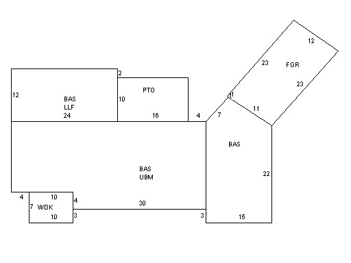
Building Description
|
|
|
| Building
Style |
Contemporary |
Foundation
Type |
Concrete |
Flooring
Type |
Hardwood |
| # of Living
Units |
1 |
Frame
Type |
Wood |
Basement
Floor |
N/A |
| Year
Built |
1950 |
Roof
Structure |
Gable/Hip |
Heating
Type |
Frcd Hot Air |
| Building
Grade |
7 1.5 |
Roof
Cover |
Rolled |
Heating
Fuel |
Oil |
| Building
Condition |
Average |
Siding |
Cedar/Redwd |
Air
Conditioning |
100% |
| Finished
Area (SF) |
1782 |
Interior
Walls |
Drywall |
# of Bsmt
Garages |
0 |
| Number
Rooms |
6 |
# of
Bedrooms |
3 |
# of Full
Baths |
1 |
| # of 3/4
Baths |
0 |
# of 1/2
Baths |
1 |
# of Other
Fixtures |
1 |
|
|
|
|
| Legal Description
|
|
|
|
PARENT LOT 17 01 016 004 / PLAN23937Q
|
|
|
| Narrative Description of Property
|
|
|
|
This property contains 3.043 acres of land mainly classified as
ONE FAMILY
with a(n) Contemporary style building, built about
1950 , having Cedar/Redwd exterior and Rolled
roof cover, with 1
unit(s), 6
room(s), 3
bedroom(s), 1
bath(s), 1 half bath(s). |
|
|
|
| Property Images
|
|
|