|
Unofficial Property Record Card - Falmouth, MA
|
|

|
|
General Property Data
|
|
|
| Parcel
ID |
17 01 016 055 |
Account
Number |
HATCHVILLE |
| Prior Parcel
ID |
-- |
| Property
Owner |
OLIVIER TRUSTEE DEBORAH A |
Property
Location |
137 ATAMANNSIT RD |
| |
D A OLIVIER 2022 REVOC LIV TR |
Property
Use |
ONE FAMILY |
| Mailing
Address |
137 ATAMANNSIT RD |
Most
Recent
Sale Date |
7/18/2022 |
| |
|
Legal
Reference |
230543 |
| City |
EAST FALMOUTH |
Grantor |
OLIVIER,DEBORAH A |
| Mailing
State |
|
Sale Price |
100 |
| ParcelZoning |
AGA |
Land Area |
2.773 acres |
|
|
|
|
|
Current Property Assessment
|
|
|
| Card 1 Value |
Building Value |
586,000 |
Xtra Features Value |
48,500 |
Land Value |
438,600 |
Total Value |
1,073,100 |
|
Total Parcel Value |
Building Value |
586,000 |
Xtra Features Value |
48,500 |
Land Value |
438,600 |
Total Value |
1,073,100 |
|
|
|
|
|
| Legal Description
|
|
|
|
PARENT LOT 17 01 016 004 / PLAN23937Q
|
|
|
| Narrative Description of Property
|
|
|
|
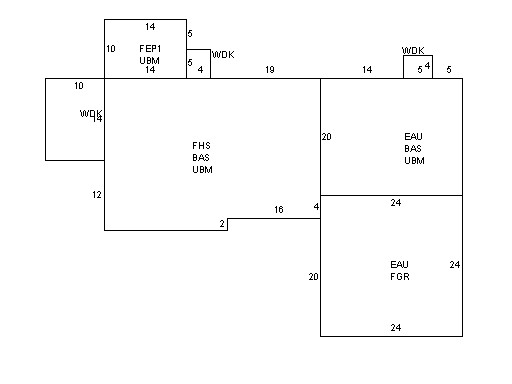
This property contains 2.773 acres of land mainly classified as
ONE FAMILY
with a(n) Cape Cod style building, built about
2011 , having Wood Shingle exterior and Asphalt
roof cover, with 1
unit(s), 8
room(s), 3
bedroom(s), 1
bath(s), 1 half bath(s). |
|