|
Unofficial Property Record Card - Falmouth, MA
|
|

|
|
General Property Data
|
|
|
| Parcel
ID |
41 01 000A 101 |
Account
Number |
MENAUHANT |
| Prior Parcel
ID |
-- |
| Property
Owner |
HOLBROOK TRUSTEE SALLY M |
Property
Location |
36 EEL RIVER RD |
| |
HOLBROOK TRUSTEE SCOTT R |
Property
Use |
ONE FAMILY |
| Mailing
Address |
36 EEL RIVER RD |
Most
Recent
Sale Date |
4/28/2022 |
| |
|
Legal
Reference |
35080-7 |
| City |
EAST FALMOUTH |
Grantor |
HOLBROOK,SALLY M |
| Mailing
State |
|
Sale Price |
100 |
| ParcelZoning |
RB |
Land Area |
0.559 acres |
|
|
|
|
|
Current Property Assessment
|
|
|
| Card 1 Value |
Building Value |
391,200 |
Xtra Features Value |
6,100 |
Land Value |
1,132,000 |
Total Value |
1,529,300 |
|
Total Parcel Value |
Building Value |
391,200 |
Xtra Features Value |
6,100 |
Land Value |
1,132,000 |
Total Value |
1,529,300 |
|
|
|
|
|
| Legal Description
|
|
|
|
FY19 SUBDIVSION PARENT LOT 41 01 000A014 PLAN 29490C
|
|
|
| Narrative Description of Property
|
|
|
|
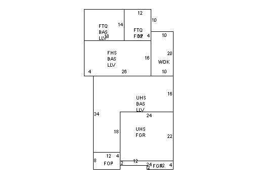
This property contains 0.559 acres of land mainly classified as
ONE FAMILY
with a(n) Cape Cod style building, built about
2018 , having Wood Shingle exterior and Asphalt
roof cover, with 1
unit(s), 7
room(s), 3
bedroom(s), 1
bath(s), 1 half bath(s). |
|