|
Unofficial Property Record Card - Falmouth, MA
|
|

|
|
General Property Data
|
|
|
| Parcel
ID |
11 01 029 246 |
Account
Number |
EAST FALMOUTH |
| Prior Parcel
ID |
-- |
| Property
Owner |
FOLEY DEBORAH J |
Property
Location |
12 SUMMIT LN |
| |
|
Property
Use |
ONE FAMILY |
| Mailing
Address |
12 SUMMIT LN |
Most
Recent
Sale Date |
11/5/2007 |
| |
|
Legal
Reference |
22452-42 |
| City |
E FALMOUTH |
Grantor |
FOLEY,DEBORAH J |
| Mailing
State |
|
Sale Price |
100 |
| ParcelZoning |
AGAA |
Land Area |
1.413 acres |
|
|
|
|
|
Current Property Assessment
|
|
|
| Card 1 Value |
Building Value |
945,700 |
Xtra Features Value |
6,000 |
Land Value |
419,800 |
Total Value |
1,371,500 |
|
Total Parcel Value |
Building Value |
945,700 |
Xtra Features Value |
6,000 |
Land Value |
419,800 |
Total Value |
1,371,500 |
|
|
|
|
|
| Legal Description
|
|
|
|
|
|
|
| Narrative Description of Property
|
|
|
|
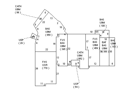
This property contains 1.413 acres of land mainly classified as
ONE FAMILY
with a(n) Contemporary style building, built about
1996 , having Clapboard exterior and Asphalt
roof cover, with 1
unit(s), 7
room(s), 4
bedroom(s), 2
bath(s), 2 half bath(s). |
|