|
Unofficial Property Record Card - Falmouth, MA
|
|

|
|
General Property Data
|
|
|
| Parcel
ID |
02 01 012A 001A |
Account
Number |
NORTH FALMOUTH |
| Prior Parcel
ID |
-- |
| Property
Owner |
HANNON BARON TRUSTEE AMY |
Property
Location |
20 BRENTON RD |
| |
HANNON JR TRUSTEE BARRY THOMAS |
Property
Use |
ONE FAMILY |
| Mailing
Address |
60 LYNDON RD |
Most
Recent
Sale Date |
12/28/2018 |
| |
|
Legal
Reference |
31756-241 |
| City |
WRENTHAM |
Grantor |
HANNON ,BARRY T |
| Mailing
State |
|
Sale Price |
1 |
| ParcelZoning |
RB |
Land Area |
0.575 acres |
|
|
|
|
|
Current Property Assessment
|
|
|
| Card 1 Value |
Building Value |
232,200 |
Xtra Features Value |
3,400 |
Land Value |
730,100 |
Total Value |
965,700 |
|
Total Parcel Value |
Building Value |
232,200 |
Xtra Features Value |
3,400 |
Land Value |
730,100 |
Total Value |
965,700 |
|
|
|
|
|
|
Building Description
|
|
|
| Building
Style |
Contemporary |
Foundation
Type |
|
Flooring
Type |
Carpet |
| # of Living
Units |
1 |
Frame
Type |
|
Basement
Floor |
N/A |
| Year
Built |
1971 |
Roof
Structure |
Gable/Hip |
Heating
Type |
Hot Water |
| Building
Grade |
4 1.1 |
Roof
Cover |
Asphalt |
Heating
Fuel |
Gas |
| Building
Condition |
Average |
Siding |
Cedar/Redwd |
Air
Conditioning |
100% |
| Finished
Area (SF) |
1976 |
Interior
Walls |
Drywall |
# of Bsmt
Garages |
0 |
| Number
Rooms |
7 |
# of
Bedrooms |
4 |
# of Full
Baths |
1 |
| # of 3/4
Baths |
1 |
# of 1/2
Baths |
0 |
# of Other
Fixtures |
1 |
|
|
|
|
| Legal Description
|
|
|
|
|
|
|
| Narrative Description of Property
|
|
|
|
This property contains 0.575 acres of land mainly classified as
ONE FAMILY
with a(n) Contemporary style building, built about
1971 , having Cedar/Redwd exterior and Asphalt
roof cover, with 1
unit(s), 7
room(s), 4
bedroom(s), 1
bath(s), 0 half bath(s). |
|
|
|
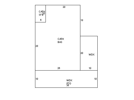
| Property Images
|
|
|