|
Unofficial Property Record Card - Falmouth, MA
|
|

|
|
General Property Data
|
|
|
| Parcel
ID |
14 04 012 001 |
Account
Number |
WEST FALMOUTH |
| Prior Parcel
ID |
-- |
| Property
Owner |
YESSAILLIAN GARY A |
Property
Location |
6 OLD SILVER LN |
| |
YESSAILLIAN MICHELINA L |
Property
Use |
ONE FAMILY |
| Mailing
Address |
9 ADAMS ST |
Most
Recent
Sale Date |
6/18/2018 |
| |
|
Legal
Reference |
31346-77 |
| City |
WESTWOOD |
Grantor |
PROVOST,ROBIN J |
| Mailing
State |
|
Sale Price |
880,000 |
| ParcelZoning |
RB |
Land Area |
0.929 acres |
|
|
|
|
|
Current Property Assessment
|
|
|
| Card 1 Value |
Building Value |
790,000 |
Xtra Features Value |
7,900 |
Land Value |
358,500 |
Total Value |
1,156,400 |
|
Total Parcel Value |
Building Value |
790,000 |
Xtra Features Value |
7,900 |
Land Value |
358,500 |
Total Value |
1,156,400 |
|
|
|
|
|
| Legal Description
|
|
|
|
PARENT LOTS 14 01 012 001 & 14 04 012A 001 / PLAN 586/53
|
|
|
| Narrative Description of Property
|
|
|
|
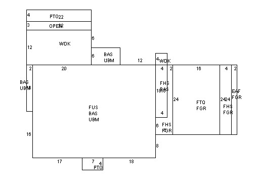
This property contains 0.929 acres of land mainly classified as
ONE FAMILY
with a(n) Colonial style building, built about
2002 , having Wood Shingle exterior and Asphalt
roof cover, with 1
unit(s), 7
room(s), 4
bedroom(s), 2
bath(s), 1 half bath(s). |
|