|
Unofficial Property Record Card - Falmouth, MA
|
|

|
|
General Property Data
|
|
|
| Parcel
ID |
02A 11 028 002 |
Account
Number |
NORTH FALMOUTH |
| Prior Parcel
ID |
-- |
| Property
Owner |
COLLARD TRUSTEE TIMOTHY J |
Property
Location |
23 BRENTON RD WEST |
| |
ARTICLE VI A F COLLARD RES TR |
Property
Use |
ONE FAMILY |
| Mailing
Address |
20 CLARK RD |
Most
Recent
Sale Date |
6/6/2022 |
| |
|
Legal
Reference |
35169-156 |
| City |
WELLESLEY |
Grantor |
KIRCHICK TRUSTEE,WILLIAM D |
| Mailing
State |
|
Sale Price |
1 |
| ParcelZoning |
RB |
Land Area |
0.576 acres |
|
|
|
|
|
Current Property Assessment
|
|
|
| Card 1 Value |
Building Value |
579,600 |
Xtra Features Value |
4,300 |
Land Value |
1,669,300 |
Total Value |
2,253,200 |
|
Total Parcel Value |
Building Value |
579,600 |
Xtra Features Value |
4,300 |
Land Value |
1,669,300 |
Total Value |
2,253,200 |
|
|
|
|
|
| Legal Description
|
|
|
|
|
|
|
| Narrative Description of Property
|
|
|
|
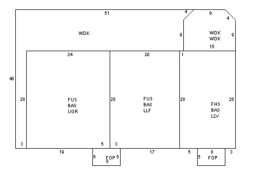
This property contains 0.576 acres of land mainly classified as
ONE FAMILY
with a(n) Contemporary style building, built about
1976 , having Wood Shingle exterior and Asphalt
roof cover, with 1
unit(s), 8
room(s), 5
bedroom(s), 4
bath(s), 0 half bath(s). |
|