|
Unofficial Property Record Card - Falmouth, MA
|
|

|
|
General Property Data
|
|
|
| Parcel
ID |
02A 11 040 000 |
Account
Number |
NORTH FALMOUTH |
| Prior Parcel
ID |
-- |
| Property
Owner |
MARTIN JR THOMAS J |
Property
Location |
7 BRENTON RD |
| |
MARTIN CATHERINE F |
Property
Use |
ONE FAMILY |
| Mailing
Address |
10 KINGS RD |
Most
Recent
Sale Date |
6/8/2018 |
| |
|
Legal
Reference |
31322-343 |
| City |
CANTON |
Grantor |
SENNOTT TRUSTEE,MARK P |
| Mailing
State |
|
Sale Price |
1,175,000 |
| ParcelZoning |
RB |
Land Area |
0.448 acres |
|
|
|
|
|
Current Property Assessment
|
|
|
| Card 1 Value |
Building Value |
503,800 |
Xtra Features Value |
2,100 |
Land Value |
722,100 |
Total Value |
1,228,000 |
|
Total Parcel Value |
Building Value |
503,800 |
Xtra Features Value |
2,100 |
Land Value |
722,100 |
Total Value |
1,228,000 |
|
|
|
|
|
| Legal Description
|
|
|
|
|
|
|
| Narrative Description of Property
|
|
|
|
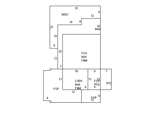
This property contains 0.448 acres of land mainly classified as
ONE FAMILY
with a(n) Conventional style building, built about
1890 , having Wood Shingle exterior and Asphalt
roof cover, with 1
unit(s), 7
room(s), 4
bedroom(s), 1
bath(s), 0 half bath(s). |
|