|
Unofficial Property Record Card - Falmouth, MA
|
|

|
|
General Property Data
|
|
|
| Parcel
ID |
15 03 006 002 |
Account
Number |
NORTH FALMOUTH |
| Prior Parcel
ID |
-- |
| Property
Owner |
LOPES ESTATE OF PAULINE B |
Property
Location |
1 NORTH FALMOUTH HWY |
| |
|
Property
Use |
ONE FAMILY |
| Mailing
Address |
1 N FALMOUTH HWY |
Most
Recent
Sale Date |
3/13/1980 |
| |
|
Legal
Reference |
01401-0868 |
| City |
NORTH FALMOUTH |
Grantor |
LOPES PAULINE B |
| Mailing
State |
|
Sale Price |
0 |
| ParcelZoning |
RB |
Land Area |
1.058 acres |
|
|
|
|
|
Current Property Assessment
|
|
|
| Card 1 Value |
Building Value |
210,600 |
Xtra Features Value |
0 |
Land Value |
195,400 |
Total Value |
406,000 |
|
Total Parcel Value |
Building Value |
210,600 |
Xtra Features Value |
0 |
Land Value |
195,400 |
Total Value |
406,000 |
|
|
|
|
|
|
Building Description
|
|
|
| Building
Style |
Contemporary |
Foundation
Type |
|
Flooring
Type |
Hardwood |
| # of Living
Units |
1 |
Frame
Type |
Wood |
Basement
Floor |
N/A |
| Year
Built |
1960 |
Roof
Structure |
Gable/Hip |
Heating
Type |
Frcd Hot Air |
| Building
Grade |
4 1.1 |
Roof
Cover |
Asphalt |
Heating
Fuel |
Oil |
| Building
Condition |
Average |
Siding |
Wood on Shth |
Air
Conditioning |
0% |
| Finished
Area (SF) |
1632 |
Interior
Walls |
Drywall |
# of Bsmt
Garages |
1 |
| Number
Rooms |
6 |
# of
Bedrooms |
3 |
# of Full
Baths |
2 |
| # of 3/4
Baths |
0 |
# of 1/2
Baths |
0 |
# of Other
Fixtures |
0 |
|
|
|
|
| Legal Description
|
|
|
|
|
|
|
| Narrative Description of Property
|
|
|
|
This property contains 1.058 acres of land mainly classified as
ONE FAMILY
with a(n) Contemporary style building, built about
1960 , having Wood on Shth exterior and Asphalt
roof cover, with 1
unit(s), 6
room(s), 3
bedroom(s), 2
bath(s), 0 half bath(s). |
|
|
|
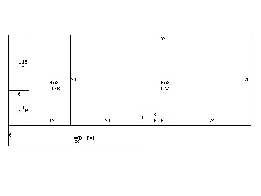
| Property Images
|
|
|