|
Unofficial Property Record Card - Falmouth, MA
|
|

|
|
General Property Data
|
|
|
| Parcel
ID |
18 02 006 002 |
Account
Number |
HATCHVILLE |
| Prior Parcel
ID |
-- |
| Property
Owner |
BARNSTABLE COUNTY |
Property
Location |
1178 NATHAN S ELLIS HWY |
| |
AGRICULTURAL SOCIETY INC |
Property
Use |
FAIR GRDS |
| Mailing
Address |
1220 NATHAN ELLIS HWY |
Most
Recent
Sale Date |
2/13/1980 |
| |
|
Legal
Reference |
80935 |
| City |
EAST FALMOUTH |
Grantor |
|
| Mailing
State |
|
Sale Price |
110,000 |
| ParcelZoning |
AGA |
Land Area |
13.303 acres |
|
|
|
|
|
Current Property Assessment
|
|
|
| Card 1 Value |
Building Value |
24,100 |
Xtra Features Value |
13,100 |
Land Value |
895,900 |
Total Value |
933,100 |
|
Total Parcel Value |
Building Value |
24,100 |
Xtra Features Value |
13,100 |
Land Value |
895,900 |
Total Value |
933,100 |
|
|
|
|
|
|
Building Description
|
|
|
| Building
Style |
AccessoryBld |
Foundation
Type |
Slab |
Flooring
Type |
Vinyl |
| # of Living
Units |
0 |
Frame
Type |
Wood |
Basement
Floor |
N/A |
| Year
Built |
1982 |
Roof
Structure |
Gable/Hip |
Heating
Type |
None |
| Building
Grade |
2 .9 |
Roof
Cover |
Metal |
Heating
Fuel |
NONE |
| Building
Condition |
Average |
Siding |
Prefab Wood |
Air
Conditioning |
0% |
| Finished
Area (SF) |
480 |
Interior
Walls |
Drywall |
# of Bsmt
Garages |
0 |
| Number
Rooms |
0 |
# of
Bedrooms |
0 |
# of Full
Baths |
0 |
| # of 3/4
Baths |
0 |
# of 1/2
Baths |
1 |
# of Other
Fixtures |
1 |
|
|
|
|
| Legal Description
|
|
|
|
|
|
|
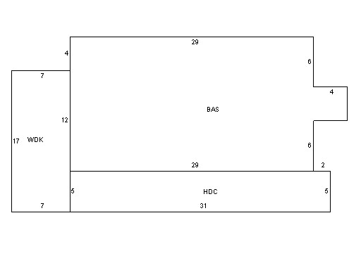
| Narrative Description of Property
|
|
|
|
This property contains 13.303 acres of land mainly classified as
FAIR GRDS
with a(n) AccessoryBld style building, built about
1982 , having Prefab Wood exterior and Metal
roof cover, with 0
unit(s), 0
room(s), 0
bedroom(s), 0
bath(s), 1 half bath(s). |
|
|
|
| Property Images
|
|
|