|
Unofficial Property Record Card - Falmouth, MA
|
|

|
|
General Property Data
|
|
|
| Parcel
ID |
02 01 015A 001C |
Account
Number |
NORTH FALMOUTH |
| Prior Parcel
ID |
-- |
| Property
Owner |
PURDY STEVEN J |
Property
Location |
43 BRYANT POINT RD |
| |
WOOD ALISSA M |
Property
Use |
ONE FAMILY |
| Mailing
Address |
469 20TH ST |
Most
Recent
Sale Date |
5/30/2008 |
| |
|
Legal
Reference |
22947-319 |
| City |
SANTA MONICA |
Grantor |
SOVIERO TRUSTEE,THOMAS T |
| Mailing
State |
|
Sale Price |
2,150,000 |
| ParcelZoning |
RB |
Land Area |
0.521 acres |
|
|
|
|
|
Current Property Assessment
|
|
|
| Card 1 Value |
Building Value |
557,400 |
Xtra Features Value |
1,000 |
Land Value |
2,036,700 |
Total Value |
2,595,100 |
|
Total Parcel Value |
Building Value |
557,400 |
Xtra Features Value |
1,000 |
Land Value |
2,036,700 |
Total Value |
2,595,100 |
|
|
|
|
|
| Legal Description
|
|
|
|
|
|
|
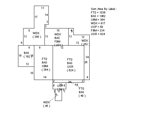
| Narrative Description of Property
|
|
|
|
This property contains 0.521 acres of land mainly classified as
ONE FAMILY
with a(n) Gambrel style building, built about
1980 , having Wood Shingle exterior and Asphalt
roof cover, with 1
unit(s), 7
room(s), 4
bedroom(s), 2
bath(s), 0 half bath(s). |
|